You are here: Home > Network List > OK - Oklahoma Seismic Network Stations List
> Station NOKA Waynoka, Oklahoma, USA > Earthquake Result Viewer
NOKA Waynoka, Oklahoma, USA - Earthquake Result Viewer
| Earthquake location: |
Dodecanese Islands, Greece |
| Earthquake latitude/longitude: |
36.9/27.5 |
| Earthquake time(UTC): |
2017/07/20 (201) 22:31:12 GMT |
| Earthquake Depth: |
10 km |
| Earthquake Magnitude: |
6.7 Mww |
| Earthquake Catalog/Contributor: |
NEIC PDE/us |
|
| Network: |
OK Oklahoma Seismic Network |
| Station: |
NOKA Waynoka, Oklahoma, USA |
| Lat/Lon: |
36.63 N/98.93 W |
| Elevation: |
476 m |
|
| Distance: |
91.5 deg |
| Az: |
319.628 deg |
| Baz: |
40.175 deg |
| Ray Param: |
0.041595485 |
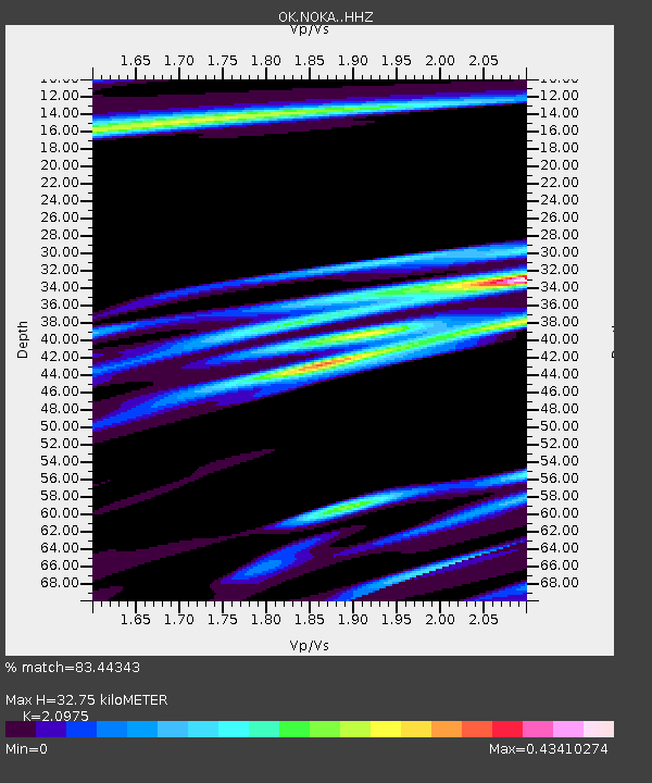
| Estimated Moho Depth: |
32.75 km |
| Estimated Crust Vp/Vs: |
2.10 |
| Assumed Crust Vp: |
6.426 km/s |
| Estimated Crust Vs: |
3.064 km/s |
| Estimated Crust Poisson's Ratio: |
0.35 |
|
| Radial Match: |
83.44343 % |
| Radial Bump: |
391 |
| Transverse Match: |
64.40843 % |
| Transverse Bump: |
400 |
| SOD ConfigId: |
13570011 |
| Insert Time: |
2019-04-28 10:44:40.419 +0000 |
| GWidth: |
2.5 |
| Max Bumps: |
400 |
| Tol: |
0.001 |
|

Signal To Noise
| Channel | StoN | STA | LTA |
| OK:NOKA: :HHZ:20170720T22:43:46.813977Z | 8.245078 | 1.8234305E-6 | 2.2115381E-7 |
| OK:NOKA: :HHN:20170720T22:43:46.813977Z | 2.1759276 | 7.2494464E-7 | 3.331658E-7 |
| OK:NOKA: :HHE:20170720T22:43:46.813977Z | 1.7534986 | 4.9325854E-7 | 2.8129966E-7 |
| Arrivals |
| Ps | 5.7 SECOND |
| PpPs | 16 SECOND |
| PsPs/PpSs | 21 SECOND |


