You are here: Home > Network List > GT - Global Telemetered Seismograph Network (USAF/USGS) Stations List
> Station LPAZ La Paz , Bolivia > Earthquake Result Viewer
LPAZ La Paz , Bolivia - Earthquake Result Viewer
| Earthquake location: |
Southern East Pacific Rise |
| Earthquake latitude/longitude: |
-55.8/-123.1 |
| Earthquake time(UTC): |
2015/12/24 (358) 19:44:03 GMT |
| Earthquake Depth: |
12 km |
| Earthquake Magnitude: |
6.2 MWW, 6.1 MWB, 6.2 MWC |
| Earthquake Catalog/Contributor: |
NEIC PDE/NEIC COMCAT |
|
| Network: |
GT Global Telemetered Seismograph Network (USAF/USGS) |
| Station: |
LPAZ La Paz , Bolivia |
| Lat/Lon: |
16.17 S/68.08 W |
| Elevation: |
4817 m |
|
| Distance: |
57.3 deg |
| Az: |
69.29 deg |
| Baz: |
213.387 deg |
| Ray Param: |
0.06354676 |
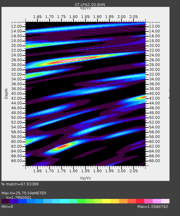
| Estimated Moho Depth: |
25.75 km |
| Estimated Crust Vp/Vs: |
1.80 |
| Assumed Crust Vp: |
6.454 km/s |
| Estimated Crust Vs: |
3.595 km/s |
| Estimated Crust Poisson's Ratio: |
0.27 |
|
| Radial Match: |
87.93399 % |
| Radial Bump: |
400 |
| Transverse Match: |
77.32867 % |
| Transverse Bump: |
400 |
| SOD ConfigId: |
1399611 |
| Insert Time: |
2016-01-28 00:27:54.103 +0000 |
| GWidth: |
2.5 |
| Max Bumps: |
400 |
| Tol: |
0.001 |
|

Signal To Noise
| Channel | StoN | STA | LTA |
| GT:LPAZ:00:BHZ:20151224T19:53:18.973994Z | 3.3832326 | 2.1898353E-7 | 6.4726116E-8 |
| GT:LPAZ:00:BHN:20151224T19:53:18.973994Z | 2.002457 | 7.715182E-8 | 3.8528576E-8 |
| GT:LPAZ:00:BHE:20151224T19:53:18.973994Z | 1.6065733 | 7.5415564E-8 | 4.6941874E-8 |
| Arrivals |
| Ps | 3.3 SECOND |
| PpPs | 11 SECOND |
| PsPs/PpSs | 14 SECOND |


