You are here: Home > Network List > TA - USArray Transportable Network (new EarthScope stations) Stations List
> Station 833A Chaparral WMA, Artesia Wells, TX, USA > Earthquake Result Viewer
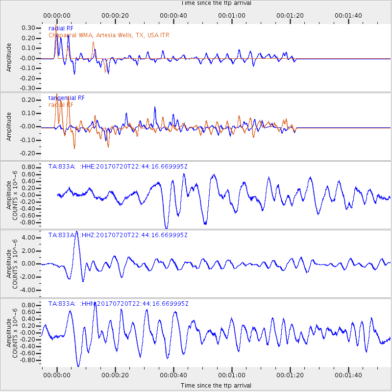
833A Chaparral WMA, Artesia Wells, TX, USA - Earthquake Result Viewer
*The percent match for this event was below the threshold and hence no stack was calculated.
| Earthquake location: |
Dodecanese Islands, Greece |
| Earthquake latitude/longitude: |
36.9/27.5 |
| Earthquake time(UTC): |
2017/07/20 (201) 22:31:12 GMT |
| Earthquake Depth: |
10 km |
| Earthquake Magnitude: |
6.7 Mww |
| Earthquake Catalog/Contributor: |
NEIC PDE/us |
|
| Network: |
TA USArray Transportable Network (new EarthScope stations) |
| Station: |
833A Chaparral WMA, Artesia Wells, TX, USA |
| Lat/Lon: |
28.32 N/99.39 W |
| Elevation: |
171 m |
|
| Distance: |
98.1 deg |
| Az: |
314.555 deg |
| Baz: |
40.355 deg |
| Ray Param: |
$rayparam |
*The percent match for this event was below the threshold and hence was not used in the summary stack. |
|
| Radial Match: |
79.14983 % |
| Radial Bump: |
395 |
| Transverse Match: |
75.47223 % |
| Transverse Bump: |
368 |
| SOD ConfigId: |
13570011 |
| Insert Time: |
2019-04-28 10:45:50.916 +0000 |
| GWidth: |
2.5 |
| Max Bumps: |
400 |
| Tol: |
0.001 |
|
Signal To Noise
| Channel | StoN | STA | LTA |
| TA:833A: :HHZ:20170720T22:44:16.669995Z | 8.348738 | 1.0712812E-6 | 1.2831654E-7 |
| TA:833A: :HHN:20170720T22:44:16.669995Z | 3.3215697 | 2.8759712E-7 | 8.65847E-8 |
| TA:833A: :HHE:20170720T22:44:16.669995Z | 2.2218466 | 2.3865616E-7 | 1.0741342E-7 |
| Arrivals |
| Ps | |
| PpPs | |
| PsPs/PpSs | |


