You are here: Home > Network List > TA - USArray Transportable Network (new EarthScope stations) Stations List
> Station 435B Jarrell, TX, USA > Earthquake Result Viewer
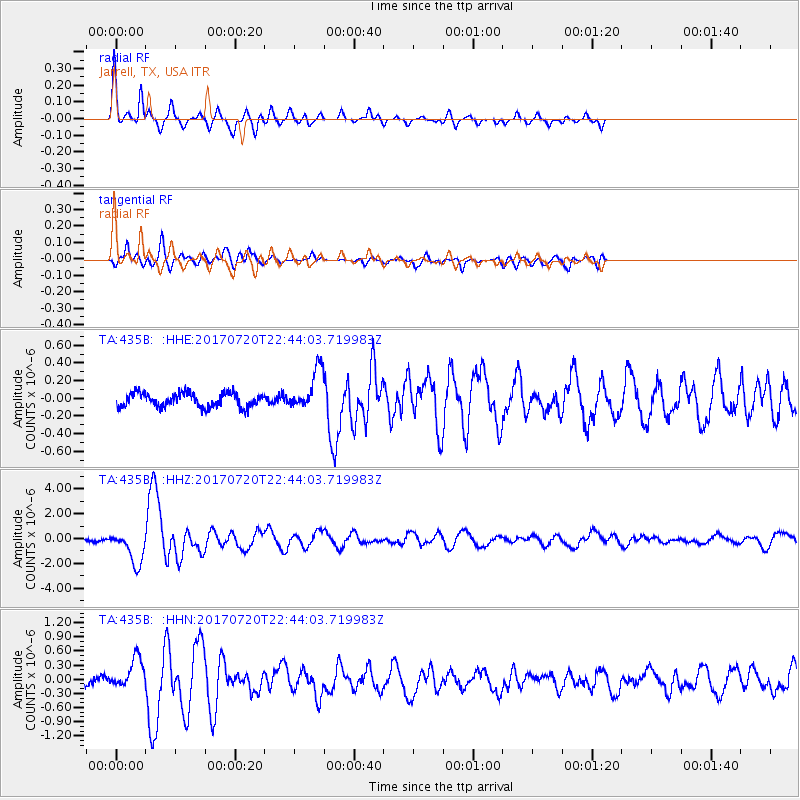
435B Jarrell, TX, USA - Earthquake Result Viewer

| Earthquake location: |
Dodecanese Islands, Greece |
| Earthquake latitude/longitude: |
36.9/27.5 |
| Earthquake time(UTC): |
2017/07/20 (201) 22:31:12 GMT |
| Earthquake Depth: |
10 km |
| Earthquake Magnitude: |
6.7 Mww |
| Earthquake Catalog/Contributor: |
NEIC PDE/us |
|
| Network: |
TA USArray Transportable Network (new EarthScope stations) |
| Station: |
435B Jarrell, TX, USA |
| Lat/Lon: |
30.78 N/97.58 W |
| Elevation: |
248 m |
|
| Distance: |
95.2 deg |
| Az: |
314.964 deg |
| Baz: |
41.195 deg |
| Ray Param: |
0.040838715 |
| Estimated Moho Depth: |
24.0 km |
| Estimated Crust Vp/Vs: |
1.60 |
| Assumed Crust Vp: |
6.347 km/s |
| Estimated Crust Vs: |
3.967 km/s |
| Estimated Crust Poisson's Ratio: |
0.18 |
|
| Radial Match: |
92.70506 % |
| Radial Bump: |
316 |
| Transverse Match: |
72.994545 % |
| Transverse Bump: |
400 |
| SOD ConfigId: |
13570011 |
| Insert Time: |
2019-04-28 10:45:50.883 +0000 |
| GWidth: |
2.5 |
| Max Bumps: |
400 |
| Tol: |
0.001 |
|
Signal To Noise
| Channel | StoN | STA | LTA |
| TA:435B: :HHZ:20170720T22:44:03.719983Z | 12.409475 | 1.3350017E-6 | 1.0757922E-7 |
| TA:435B: :HHN:20170720T22:44:03.719983Z | 3.9970553 | 3.2180498E-7 | 8.051051E-8 |
| TA:435B: :HHE:20170720T22:44:03.719983Z | 3.0309558 | 2.3713562E-7 | 7.82379E-8 |
| Arrivals |
| Ps | 2.3 SECOND |
| PpPs | 9.6 SECOND |
| PsPs/PpSs | 12 SECOND |


