You are here: Home > Network List > TA - USArray Transportable Network (new EarthScope stations) Stations List
> Station BGNE Belgrade, NE, USA > Earthquake Result Viewer
BGNE Belgrade, NE, USA - Earthquake Result Viewer
| Earthquake location: |
Dodecanese Islands, Greece |
| Earthquake latitude/longitude: |
36.9/27.5 |
| Earthquake time(UTC): |
2017/07/20 (201) 22:31:12 GMT |
| Earthquake Depth: |
10 km |
| Earthquake Magnitude: |
6.7 Mww |
| Earthquake Catalog/Contributor: |
NEIC PDE/us |
|
| Network: |
TA USArray Transportable Network (new EarthScope stations) |
| Station: |
BGNE Belgrade, NE, USA |
| Lat/Lon: |
41.41 N/98.15 W |
| Elevation: |
573 m |
|
| Distance: |
87.5 deg |
| Az: |
322.255 deg |
| Baz: |
40.688 deg |
| Ray Param: |
0.04327786 |
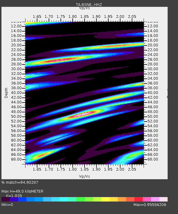
| Estimated Moho Depth: |
49.0 km |
| Estimated Crust Vp/Vs: |
1.84 |
| Assumed Crust Vp: |
6.53 km/s |
| Estimated Crust Vs: |
3.559 km/s |
| Estimated Crust Poisson's Ratio: |
0.29 |
|
| Radial Match: |
94.90287 % |
| Radial Bump: |
400 |
| Transverse Match: |
77.987785 % |
| Transverse Bump: |
400 |
| SOD ConfigId: |
13570011 |
| Insert Time: |
2019-04-28 10:45:53.690 +0000 |
| GWidth: |
2.5 |
| Max Bumps: |
400 |
| Tol: |
0.001 |
|

Signal To Noise
| Channel | StoN | STA | LTA |
| TA:BGNE: :HHZ:20170720T22:43:28.010022Z | 9.467957 | 4.636193E-6 | 4.8967195E-7 |
| TA:BGNE: :HHN:20170720T22:43:28.010022Z | 2.824093 | 1.3528802E-6 | 4.790494E-7 |
| TA:BGNE: :HHE:20170720T22:43:28.010022Z | 2.2747478 | 1.4166822E-6 | 6.2278644E-7 |
| Arrivals |
| Ps | 6.4 SECOND |
| PpPs | 21 SECOND |
| PsPs/PpSs | 27 SECOND |


