You are here: Home > Network List > TA - USArray Transportable Network (new EarthScope stations) Stations List
> Station E24K Your Creek, AK, USA > Earthquake Result Viewer
E24K Your Creek, AK, USA - Earthquake Result Viewer
| Earthquake location: |
Dodecanese Islands, Greece |
| Earthquake latitude/longitude: |
36.9/27.5 |
| Earthquake time(UTC): |
2017/07/20 (201) 22:31:12 GMT |
| Earthquake Depth: |
10 km |
| Earthquake Magnitude: |
6.7 Mww |
| Earthquake Catalog/Contributor: |
NEIC PDE/us |
|
| Network: |
TA USArray Transportable Network (new EarthScope stations) |
| Station: |
E24K Your Creek, AK, USA |
| Lat/Lon: |
68.07 N/148.49 W |
| Elevation: |
847 m |
|
| Distance: |
75.3 deg |
| Az: |
358.426 deg |
| Baz: |
3.359 deg |
| Ray Param: |
0.051795054 |
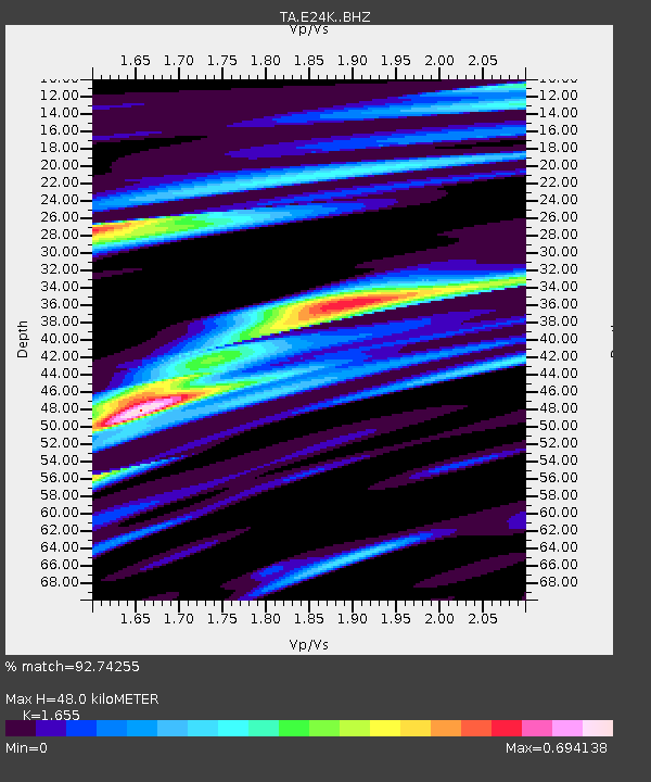
| Estimated Moho Depth: |
48.0 km |
| Estimated Crust Vp/Vs: |
1.65 |
| Assumed Crust Vp: |
6.316 km/s |
| Estimated Crust Vs: |
3.816 km/s |
| Estimated Crust Poisson's Ratio: |
0.21 |
|
| Radial Match: |
92.74255 % |
| Radial Bump: |
400 |
| Transverse Match: |
87.04351 % |
| Transverse Bump: |
400 |
| SOD ConfigId: |
13570011 |
| Insert Time: |
2019-04-28 10:46:02.095 +0000 |
| GWidth: |
2.5 |
| Max Bumps: |
400 |
| Tol: |
0.001 |
|

Signal To Noise
| Channel | StoN | STA | LTA |
| TA:E24K: :BHZ:20170720T22:42:23.450024Z | 60.703968 | 2.8810684E-6 | 4.7460958E-8 |
| TA:E24K: :BHN:20170720T22:42:23.450024Z | 23.904705 | 1.0277839E-6 | 4.2995048E-8 |
| TA:E24K: :BHE:20170720T22:42:23.450024Z | 2.5041885 | 8.868514E-8 | 3.5414722E-8 |
| Arrivals |
| Ps | 5.1 SECOND |
| PpPs | 20 SECOND |
| PsPs/PpSs | 25 SECOND |


