You are here: Home > Network List > TA - USArray Transportable Network (new EarthScope stations) Stations List
> Station F22K John River, AK, USA > Earthquake Result Viewer
F22K John River, AK, USA - Earthquake Result Viewer
| Earthquake location: |
Dodecanese Islands, Greece |
| Earthquake latitude/longitude: |
36.9/27.5 |
| Earthquake time(UTC): |
2017/07/20 (201) 22:31:12 GMT |
| Earthquake Depth: |
10 km |
| Earthquake Magnitude: |
6.7 Mww |
| Earthquake Catalog/Contributor: |
NEIC PDE/us |
|
| Network: |
TA USArray Transportable Network (new EarthScope stations) |
| Station: |
F22K John River, AK, USA |
| Lat/Lon: |
67.51 N/152.18 W |
| Elevation: |
546 m |
|
| Distance: |
75.9 deg |
| Az: |
359.856 deg |
| Baz: |
0.3 deg |
| Ray Param: |
0.051380817 |
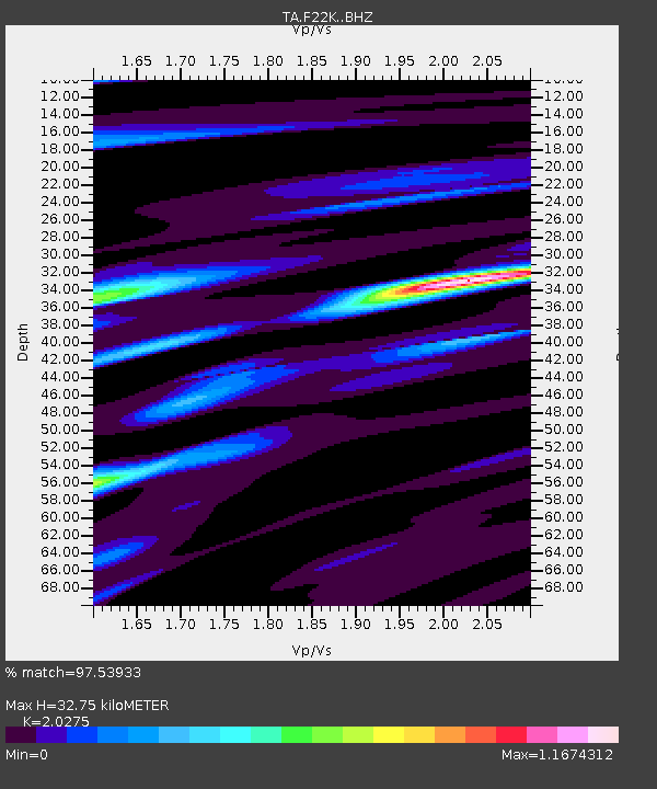
| Estimated Moho Depth: |
32.75 km |
| Estimated Crust Vp/Vs: |
2.03 |
| Assumed Crust Vp: |
6.455 km/s |
| Estimated Crust Vs: |
3.184 km/s |
| Estimated Crust Poisson's Ratio: |
0.34 |
|
| Radial Match: |
97.53933 % |
| Radial Bump: |
400 |
| Transverse Match: |
92.34862 % |
| Transverse Bump: |
400 |
| SOD ConfigId: |
13570011 |
| Insert Time: |
2019-04-28 10:46:06.957 +0000 |
| GWidth: |
2.5 |
| Max Bumps: |
400 |
| Tol: |
0.001 |
|

Signal To Noise
| Channel | StoN | STA | LTA |
| TA:F22K: :BHZ:20170720T22:42:26.974988Z | 60.517323 | 3.3477215E-6 | 5.5318402E-8 |
| TA:F22K: :BHN:20170720T22:42:26.974988Z | 30.156315 | 1.329123E-6 | 4.4074454E-8 |
| TA:F22K: :BHE:20170720T22:42:26.974988Z | 5.536163 | 1.5285443E-7 | 2.7610175E-8 |
| Arrivals |
| Ps | 5.4 SECOND |
| PpPs | 15 SECOND |
| PsPs/PpSs | 20 SECOND |


