You are here: Home > Network List > TA - USArray Transportable Network (new EarthScope stations) Stations List
> Station I26K Coal Creek Mining Camp, AK, USA > Earthquake Result Viewer
I26K Coal Creek Mining Camp, AK, USA - Earthquake Result Viewer
| Earthquake location: |
Dodecanese Islands, Greece |
| Earthquake latitude/longitude: |
36.9/27.5 |
| Earthquake time(UTC): |
2017/07/20 (201) 22:31:12 GMT |
| Earthquake Depth: |
10 km |
| Earthquake Magnitude: |
6.7 Mww |
| Earthquake Catalog/Contributor: |
NEIC PDE/us |
|
| Network: |
TA USArray Transportable Network (new EarthScope stations) |
| Station: |
I26K Coal Creek Mining Camp, AK, USA |
| Lat/Lon: |
65.31 N/143.15 W |
| Elevation: |
338 m |
|
| Distance: |
77.8 deg |
| Az: |
355.98 deg |
| Baz: |
7.683 deg |
| Ray Param: |
0.050067846 |
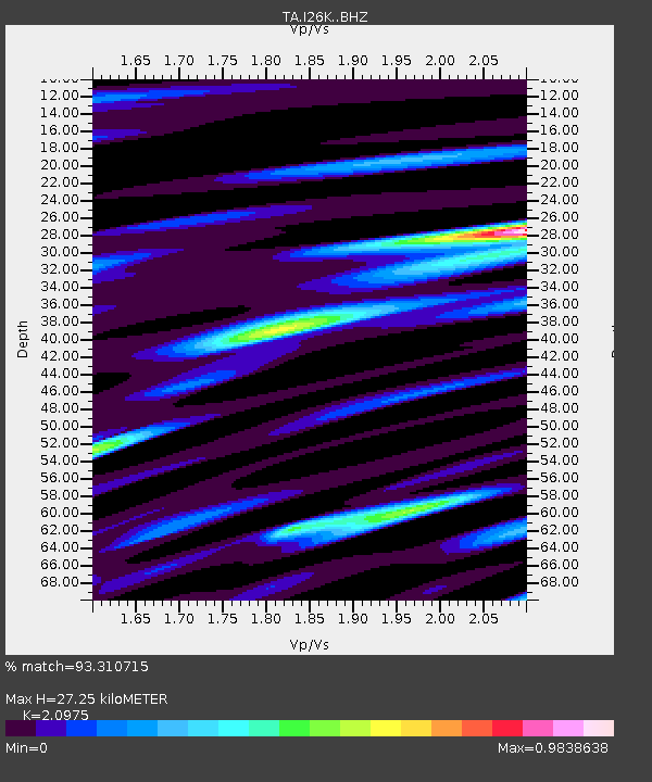
| Estimated Moho Depth: |
27.25 km |
| Estimated Crust Vp/Vs: |
2.10 |
| Assumed Crust Vp: |
6.566 km/s |
| Estimated Crust Vs: |
3.13 km/s |
| Estimated Crust Poisson's Ratio: |
0.35 |
|
| Radial Match: |
93.310715 % |
| Radial Bump: |
400 |
| Transverse Match: |
77.08296 % |
| Transverse Bump: |
400 |
| SOD ConfigId: |
13570011 |
| Insert Time: |
2019-04-28 10:46:34.620 +0000 |
| GWidth: |
2.5 |
| Max Bumps: |
400 |
| Tol: |
0.001 |
|

Signal To Noise
| Channel | StoN | STA | LTA |
| TA:I26K: :BHZ:20170720T22:42:37.899976Z | 46.846844 | 2.8718885E-6 | 6.130377E-8 |
| TA:I26K: :BHN:20170720T22:42:37.899976Z | 17.802483 | 1.015506E-6 | 5.7042943E-8 |
| TA:I26K: :BHE:20170720T22:42:37.899976Z | 4.381715 | 2.5086214E-7 | 5.7252045E-8 |
| Arrivals |
| Ps | 4.7 SECOND |
| PpPs | 13 SECOND |
| PsPs/PpSs | 17 SECOND |


