You are here: Home > Network List > TA - USArray Transportable Network (new EarthScope stations) Stations List
> Station K24K Donnelly Dome, AK, USA > Earthquake Result Viewer
K24K Donnelly Dome, AK, USA - Earthquake Result Viewer
| Earthquake location: |
Dodecanese Islands, Greece |
| Earthquake latitude/longitude: |
36.9/27.5 |
| Earthquake time(UTC): |
2017/07/20 (201) 22:31:12 GMT |
| Earthquake Depth: |
10 km |
| Earthquake Magnitude: |
6.7 Mww |
| Earthquake Catalog/Contributor: |
NEIC PDE/us |
|
| Network: |
TA USArray Transportable Network (new EarthScope stations) |
| Station: |
K24K Donnelly Dome, AK, USA |
| Lat/Lon: |
63.80 N/145.78 W |
| Elevation: |
724 m |
|
| Distance: |
79.4 deg |
| Az: |
356.952 deg |
| Baz: |
5.508 deg |
| Ray Param: |
0.048958663 |
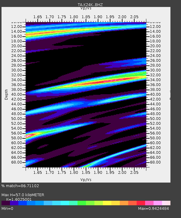
| Estimated Moho Depth: |
57.0 km |
| Estimated Crust Vp/Vs: |
1.60 |
| Assumed Crust Vp: |
6.566 km/s |
| Estimated Crust Vs: |
4.097 km/s |
| Estimated Crust Poisson's Ratio: |
0.18 |
|
| Radial Match: |
86.71102 % |
| Radial Bump: |
353 |
| Transverse Match: |
73.6736 % |
| Transverse Bump: |
400 |
| SOD ConfigId: |
13570011 |
| Insert Time: |
2019-04-28 10:46:50.827 +0000 |
| GWidth: |
2.5 |
| Max Bumps: |
400 |
| Tol: |
0.001 |
|

Signal To Noise
| Channel | StoN | STA | LTA |
| TA:K24K: :BHZ:20170720T22:42:46.849988Z | 24.245 | 5.132403E-6 | 2.1168913E-7 |
| TA:K24K: :BHN:20170720T22:42:46.849988Z | 12.30434 | 1.7391257E-6 | 1.4134245E-7 |
| TA:K24K: :BHE:20170720T22:42:46.849988Z | 1.5390905 | 2.2180556E-7 | 1.441147E-7 |
| Arrivals |
| Ps | 5.4 SECOND |
| PpPs | 22 SECOND |
| PsPs/PpSs | 27 SECOND |


