You are here: Home > Network List > TA - USArray Transportable Network (new EarthScope stations) Stations List
> Station L14K Kuka Creek, AK, USA > Earthquake Result Viewer
L14K Kuka Creek, AK, USA - Earthquake Result Viewer
| Earthquake location: |
Dodecanese Islands, Greece |
| Earthquake latitude/longitude: |
36.9/27.5 |
| Earthquake time(UTC): |
2017/07/20 (201) 22:31:12 GMT |
| Earthquake Depth: |
10 km |
| Earthquake Magnitude: |
6.7 Mww |
| Earthquake Catalog/Contributor: |
NEIC PDE/us |
|
| Network: |
TA USArray Transportable Network (new EarthScope stations) |
| Station: |
L14K Kuka Creek, AK, USA |
| Lat/Lon: |
61.34 N/162.68 W |
| Elevation: |
41 m |
|
| Distance: |
81.7 deg |
| Az: |
4.92 deg |
| Baz: |
351.805 deg |
| Ray Param: |
0.047397096 |
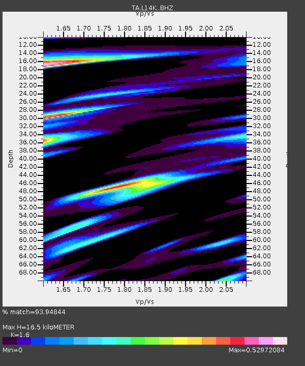
| Estimated Moho Depth: |
16.5 km |
| Estimated Crust Vp/Vs: |
1.60 |
| Assumed Crust Vp: |
6.1 km/s |
| Estimated Crust Vs: |
3.812 km/s |
| Estimated Crust Poisson's Ratio: |
0.18 |
|
| Radial Match: |
93.94844 % |
| Radial Bump: |
400 |
| Transverse Match: |
79.272255 % |
| Transverse Bump: |
400 |
| SOD ConfigId: |
13570011 |
| Insert Time: |
2019-04-28 10:46:53.584 +0000 |
| GWidth: |
2.5 |
| Max Bumps: |
400 |
| Tol: |
0.001 |
|

Signal To Noise
| Channel | StoN | STA | LTA |
| TA:L14K: :BHZ:20170720T22:42:59.000012Z | 40.92551 | 2.7595675E-6 | 6.7429035E-8 |
| TA:L14K: :BHN:20170720T22:42:59.000012Z | 9.953305 | 9.388916E-7 | 9.4329636E-8 |
| TA:L14K: :BHE:20170720T22:42:59.000012Z | 0.68757045 | 7.8359875E-8 | 1.1396632E-7 |
| Arrivals |
| Ps | 1.7 SECOND |
| PpPs | 6.8 SECOND |
| PsPs/PpSs | 8.5 SECOND |


