You are here: Home > Network List > TA - USArray Transportable Network (new EarthScope stations) Stations List
> Station L15K Ungalak Mountain, AK, USA > Earthquake Result Viewer
L15K Ungalak Mountain, AK, USA - Earthquake Result Viewer

| Earthquake location: |
Dodecanese Islands, Greece |
| Earthquake latitude/longitude: |
36.9/27.5 |
| Earthquake time(UTC): |
2017/07/20 (201) 22:31:12 GMT |
| Earthquake Depth: |
10 km |
| Earthquake Magnitude: |
6.7 Mww |
| Earthquake Catalog/Contributor: |
NEIC PDE/us |
|
| Network: |
TA USArray Transportable Network (new EarthScope stations) |
| Station: |
L15K Ungalak Mountain, AK, USA |
| Lat/Lon: |
61.68 N/161.49 W |
| Elevation: |
219 m |
|
| Distance: |
81.5 deg |
| Az: |
4.3 deg |
| Baz: |
352.764 deg |
| Ray Param: |
0.047578104 |
| Estimated Moho Depth: |
58.75 km |
| Estimated Crust Vp/Vs: |
1.60 |
| Assumed Crust Vp: |
6.182 km/s |
| Estimated Crust Vs: |
3.864 km/s |
| Estimated Crust Poisson's Ratio: |
0.18 |
|
| Radial Match: |
94.428116 % |
| Radial Bump: |
400 |
| Transverse Match: |
84.59481 % |
| Transverse Bump: |
400 |
| SOD ConfigId: |
13570011 |
| Insert Time: |
2019-04-28 10:46:54.028 +0000 |
| GWidth: |
2.5 |
| Max Bumps: |
400 |
| Tol: |
0.001 |
|
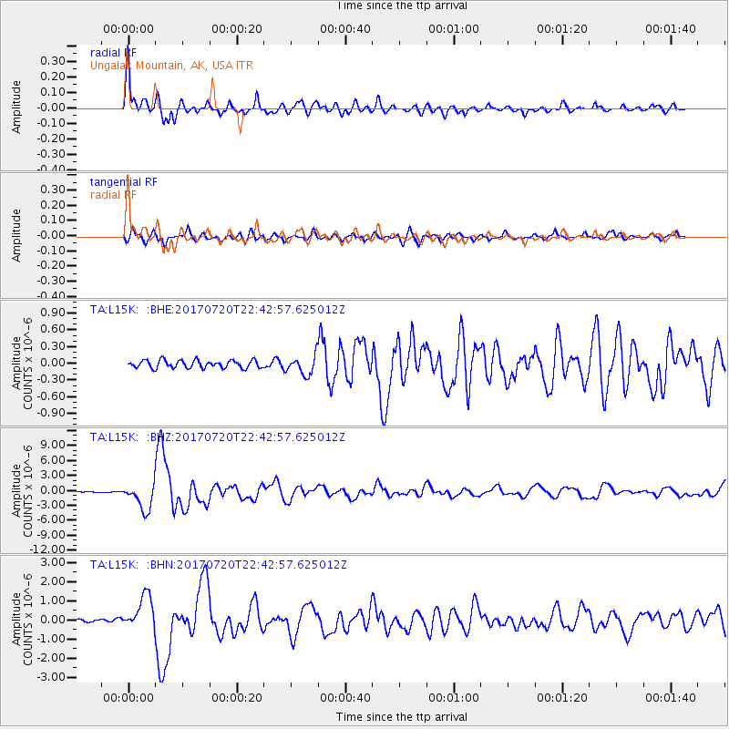
Signal To Noise
| Channel | StoN | STA | LTA |
| TA:L15K: :BHZ:20170720T22:42:57.625012Z | 42.573124 | 2.671719E-6 | 6.2756E-8 |
| TA:L15K: :BHN:20170720T22:42:57.625012Z | 14.405582 | 9.1097655E-7 | 6.323774E-8 |
| TA:L15K: :BHE:20170720T22:42:57.625012Z | 2.7020893 | 1.8372108E-7 | 6.799223E-8 |
| Arrivals |
| Ps | 5.9 SECOND |
| PpPs | 24 SECOND |
| PsPs/PpSs | 30 SECOND |


