You are here: Home > Network List > TA - USArray Transportable Network (new EarthScope stations) Stations List
> Station L17K Donlin, AK, USA > Earthquake Result Viewer
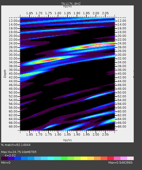
L17K Donlin, AK, USA - Earthquake Result Viewer
| Earthquake location: |
Dodecanese Islands, Greece |
| Earthquake latitude/longitude: |
36.9/27.5 |
| Earthquake time(UTC): |
2017/07/20 (201) 22:31:12 GMT |
| Earthquake Depth: |
10 km |
| Earthquake Magnitude: |
6.7 Mww |
| Earthquake Catalog/Contributor: |
NEIC PDE/us |
|
| Network: |
TA USArray Transportable Network (new EarthScope stations) |
| Station: |
L17K Donlin, AK, USA |
| Lat/Lon: |
62.13 N/158.30 W |
| Elevation: |
338 m |
|
| Distance: |
81.2 deg |
| Az: |
2.733 deg |
| Baz: |
355.337 deg |
| Ray Param: |
0.04778822 |
| Estimated Moho Depth: |
24.75 km |
| Estimated Crust Vp/Vs: |
2.02 |
| Assumed Crust Vp: |
6.276 km/s |
| Estimated Crust Vs: |
3.107 km/s |
| Estimated Crust Poisson's Ratio: |
0.34 |
|
| Radial Match: |
92.14844 % |
| Radial Bump: |
400 |
| Transverse Match: |
81.20507 % |
| Transverse Bump: |
400 |
| SOD ConfigId: |
13570011 |
| Insert Time: |
2019-04-28 10:46:55.352 +0000 |
| GWidth: |
2.5 |
| Max Bumps: |
400 |
| Tol: |
0.001 |
|

Signal To Noise
| Channel | StoN | STA | LTA |
| TA:L17K: :BHZ:20170720T22:42:56.050Z | 27.90825 | 2.6159787E-6 | 9.373496E-8 |
| TA:L17K: :BHN:20170720T22:42:56.050Z | 13.7457695 | 1.0515136E-6 | 7.649725E-8 |
| TA:L17K: :BHE:20170720T22:42:56.050Z | 0.7839813 | 7.882362E-8 | 1.0054272E-7 |
| Arrivals |
| Ps | 4.1 SECOND |
| PpPs | 12 SECOND |
| PsPs/PpSs | 16 SECOND |


