You are here: Home > Network List > TA - USArray Transportable Network (new EarthScope stations) Stations List
> Station L20K Farewell, AK, USA > Earthquake Result Viewer
L20K Farewell, AK, USA - Earthquake Result Viewer
| Earthquake location: |
Dodecanese Islands, Greece |
| Earthquake latitude/longitude: |
36.9/27.5 |
| Earthquake time(UTC): |
2017/07/20 (201) 22:31:12 GMT |
| Earthquake Depth: |
10 km |
| Earthquake Magnitude: |
6.7 Mww |
| Earthquake Catalog/Contributor: |
NEIC PDE/us |
|
| Network: |
TA USArray Transportable Network (new EarthScope stations) |
| Station: |
L20K Farewell, AK, USA |
| Lat/Lon: |
62.48 N/153.88 W |
| Elevation: |
673 m |
|
| Distance: |
80.9 deg |
| Az: |
0.629 deg |
| Baz: |
358.915 deg |
| Ray Param: |
0.04795681 |
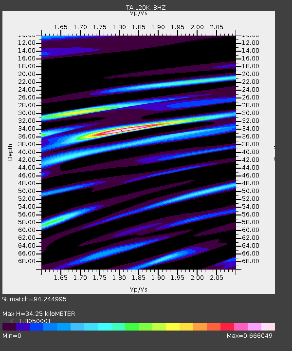
| Estimated Moho Depth: |
34.25 km |
| Estimated Crust Vp/Vs: |
1.81 |
| Assumed Crust Vp: |
6.566 km/s |
| Estimated Crust Vs: |
3.638 km/s |
| Estimated Crust Poisson's Ratio: |
0.28 |
|
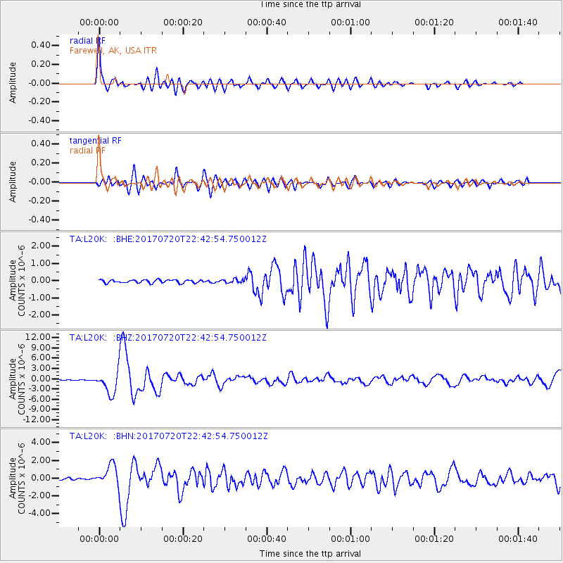
| Radial Match: |
94.244995 % |
| Radial Bump: |
400 |
| Transverse Match: |
82.09895 % |
| Transverse Bump: |
400 |
| SOD ConfigId: |
13570011 |
| Insert Time: |
2019-04-28 10:46:58.417 +0000 |
| GWidth: |
2.5 |
| Max Bumps: |
400 |
| Tol: |
0.001 |
|
Signal To Noise
| Channel | StoN | STA | LTA |
| TA:L20K: :BHZ:20170720T22:42:54.750012Z | 54.02914 | 3.4849877E-6 | 6.4502004E-8 |
| TA:L20K: :BHN:20170720T22:42:54.750012Z | 11.69369 | 1.240832E-6 | 1.0611125E-7 |
| TA:L20K: :BHE:20170720T22:42:54.750012Z | 1.2975012 | 1.1404747E-7 | 8.7897774E-8 |
| Arrivals |
| Ps | 4.3 SECOND |
| PpPs | 14 SECOND |
| PsPs/PpSs | 19 SECOND |


