You are here: Home > Network List > TA - USArray Transportable Network (new EarthScope stations) Stations List
> Station Q13A Wheeler Ranch, Garrison, UT, USA > Earthquake Result Viewer
Q13A Wheeler Ranch, Garrison, UT, USA - Earthquake Result Viewer
| Earthquake location: |
Southeast Of Honshu, Japan |
| Earthquake latitude/longitude: |
29.9/141.0 |
| Earthquake time(UTC): |
2007/12/07 (341) 00:47:37 GMT |
| Earthquake Depth: |
86 km |
| Earthquake Magnitude: |
5.8 MB, 5.9 MW, 5.8 MW |
| Earthquake Catalog/Contributor: |
WHDF/NEIC |
|
| Network: |
TA USArray Transportable Network (new EarthScope stations) |
| Station: |
Q13A Wheeler Ranch, Garrison, UT, USA |
| Lat/Lon: |
38.96 N/114.02 W |
| Elevation: |
1583 m |
|
| Distance: |
82.2 deg |
| Az: |
49.488 deg |
| Baz: |
302.177 deg |
| Ray Param: |
0.046884205 |
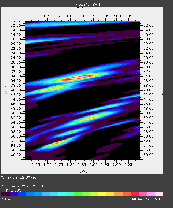
| Estimated Moho Depth: |
34.25 km |
| Estimated Crust Vp/Vs: |
1.84 |
| Assumed Crust Vp: |
6.276 km/s |
| Estimated Crust Vs: |
3.42 km/s |
| Estimated Crust Poisson's Ratio: |
0.29 |
|
| Radial Match: |
82.39797 % |
| Radial Bump: |
400 |
| Transverse Match: |
64.86711 % |
| Transverse Bump: |
400 |
| SOD ConfigId: |
2564 |
| Insert Time: |
2010-03-06 02:10:04.616 +0000 |
| GWidth: |
2.5 |
| Max Bumps: |
400 |
| Tol: |
0.001 |
|

Signal To Noise
| Channel | StoN | STA | LTA |
| TA:Q13A: :BHN:20071207T00:59:18.099004Z | 1.8390326 | 4.0439392E-7 | 2.198949E-7 |
| TA:Q13A: :BHE:20071207T00:59:18.099004Z | 0.81879723 | 1.9154375E-7 | 2.3393308E-7 |
| TA:Q13A: :BHZ:20071207T00:59:18.099004Z | 2.215821 | 4.973175E-7 | 2.2443938E-7 |
| Arrivals |
| Ps | 4.7 SECOND |
| PpPs | 15 SECOND |
| PsPs/PpSs | 20 SECOND |


