You are here: Home > Network List > TA - USArray Transportable Network (new EarthScope stations) Stations List
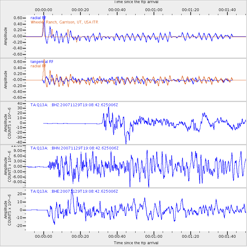
> Station Q13A Wheeler Ranch, Garrison, UT, USA > Earthquake Result Viewer
Q13A Wheeler Ranch, Garrison, UT, USA - Earthquake Result Viewer
| Earthquake location: |
Windward Islands |
| Earthquake latitude/longitude: |
15.0/-61.3 |
| Earthquake time(UTC): |
2007/11/29 (333) 19:00:19 GMT |
| Earthquake Depth: |
148 km |
| Earthquake Magnitude: |
6.9 MB, 7.4 MW, 7.4 MW |
| Earthquake Catalog/Contributor: |
WHDF/NEIC |
|
| Network: |
TA USArray Transportable Network (new EarthScope stations) |
| Station: |
Q13A Wheeler Ranch, Garrison, UT, USA |
| Lat/Lon: |
38.96 N/114.02 W |
| Elevation: |
1583 m |
|
| Distance: |
51.9 deg |
| Az: |
307.947 deg |
| Baz: |
102.179 deg |
| Ray Param: |
0.06660116 |
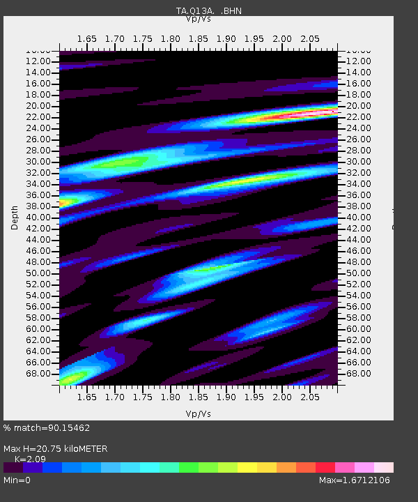
| Estimated Moho Depth: |
20.75 km |
| Estimated Crust Vp/Vs: |
2.09 |
| Assumed Crust Vp: |
6.276 km/s |
| Estimated Crust Vs: |
3.003 km/s |
| Estimated Crust Poisson's Ratio: |
0.35 |
|
| Radial Match: |
90.15462 % |
| Radial Bump: |
400 |
| Transverse Match: |
83.84112 % |
| Transverse Bump: |
400 |
| SOD ConfigId: |
2564 |
| Insert Time: |
2010-03-06 02:10:06.818 +0000 |
| GWidth: |
2.5 |
| Max Bumps: |
400 |
| Tol: |
0.001 |
|
Signal To Noise
| Channel | StoN | STA | LTA |
| TA:Q13A: :BHN:20071129T19:08:42.625006Z | 4.207963 | 9.75596E-7 | 2.3184519E-7 |
| TA:Q13A: :BHE:20071129T19:08:42.625006Z | 16.581373 | 3.5315788E-6 | 2.1298469E-7 |
| TA:Q13A: :BHZ:20071129T19:08:42.625006Z | 32.064213 | 8.50652E-6 | 2.652964E-7 |
| Arrivals |
| Ps | 3.8 SECOND |
| PpPs | 9.8 SECOND |
| PsPs/PpSs | 14 SECOND |


