You are here: Home > Network List > TA - USArray Transportable Network (new EarthScope stations) Stations List
> Station O30N Mendenhall, YT, Canada > Earthquake Result Viewer
O30N Mendenhall, YT, Canada - Earthquake Result Viewer
| Earthquake location: |
Dodecanese Islands, Greece |
| Earthquake latitude/longitude: |
36.9/27.5 |
| Earthquake time(UTC): |
2017/07/20 (201) 22:31:12 GMT |
| Earthquake Depth: |
10 km |
| Earthquake Magnitude: |
6.7 Mww |
| Earthquake Catalog/Contributor: |
NEIC PDE/us |
|
| Network: |
TA USArray Transportable Network (new EarthScope stations) |
| Station: |
O30N Mendenhall, YT, Canada |
| Lat/Lon: |
60.77 N/136.09 W |
| Elevation: |
821 m |
|
| Distance: |
81.7 deg |
| Az: |
351.925 deg |
| Baz: |
13.255 deg |
| Ray Param: |
0.047403175 |
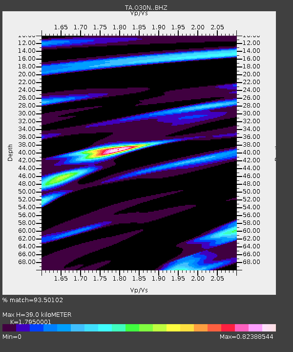
| Estimated Moho Depth: |
39.0 km |
| Estimated Crust Vp/Vs: |
1.80 |
| Assumed Crust Vp: |
6.566 km/s |
| Estimated Crust Vs: |
3.658 km/s |
| Estimated Crust Poisson's Ratio: |
0.27 |
|
| Radial Match: |
93.50102 % |
| Radial Bump: |
400 |
| Transverse Match: |
80.2248 % |
| Transverse Bump: |
400 |
| SOD ConfigId: |
13570011 |
| Insert Time: |
2019-04-28 10:47:31.146 +0000 |
| GWidth: |
2.5 |
| Max Bumps: |
400 |
| Tol: |
0.001 |
|

Signal To Noise
| Channel | StoN | STA | LTA |
| TA:O30N: :BHZ:20170720T22:42:58.899976Z | 38.078392 | 2.6587686E-6 | 6.982355E-8 |
| TA:O30N: :BHN:20170720T22:42:58.899976Z | 14.948944 | 9.481949E-7 | 6.3428885E-8 |
| TA:O30N: :BHE:20170720T22:42:58.899976Z | 5.8465037 | 3.3747142E-7 | 5.772192E-8 |
| Arrivals |
| Ps | 4.9 SECOND |
| PpPs | 16 SECOND |
| PsPs/PpSs | 21 SECOND |


