You are here: Home > Network List > TA - USArray Transportable Network (new EarthScope stations) Stations List
> Station Q13A Wheeler Ranch, Garrison, UT, USA > Earthquake Result Viewer
Q13A Wheeler Ranch, Garrison, UT, USA - Earthquake Result Viewer
| Earthquake location: |
Kuril Islands |
| Earthquake latitude/longitude: |
45.8/150.1 |
| Earthquake time(UTC): |
2007/09/03 (246) 16:14:53 GMT |
| Earthquake Depth: |
94 km |
| Earthquake Magnitude: |
6.3 MB, 6.2 MW, 6.2 ME |
| Earthquake Catalog/Contributor: |
WHDF/NEIC |
|
| Network: |
TA USArray Transportable Network (new EarthScope stations) |
| Station: |
Q13A Wheeler Ranch, Garrison, UT, USA |
| Lat/Lon: |
38.96 N/114.02 W |
| Elevation: |
1583 m |
|
| Distance: |
67.0 deg |
| Az: |
57.438 deg |
| Baz: |
310.913 deg |
| Ray Param: |
0.057033703 |
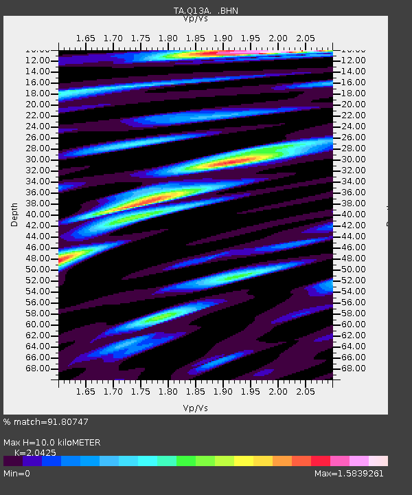
| Estimated Moho Depth: |
10.0 km |
| Estimated Crust Vp/Vs: |
2.04 |
| Assumed Crust Vp: |
6.276 km/s |
| Estimated Crust Vs: |
3.073 km/s |
| Estimated Crust Poisson's Ratio: |
0.34 |
|
| Radial Match: |
91.80747 % |
| Radial Bump: |
400 |
| Transverse Match: |
86.96215 % |
| Transverse Bump: |
400 |
| SOD ConfigId: |
2564 |
| Insert Time: |
2010-03-06 02:10:24.334 +0000 |
| GWidth: |
2.5 |
| Max Bumps: |
400 |
| Tol: |
0.001 |
|
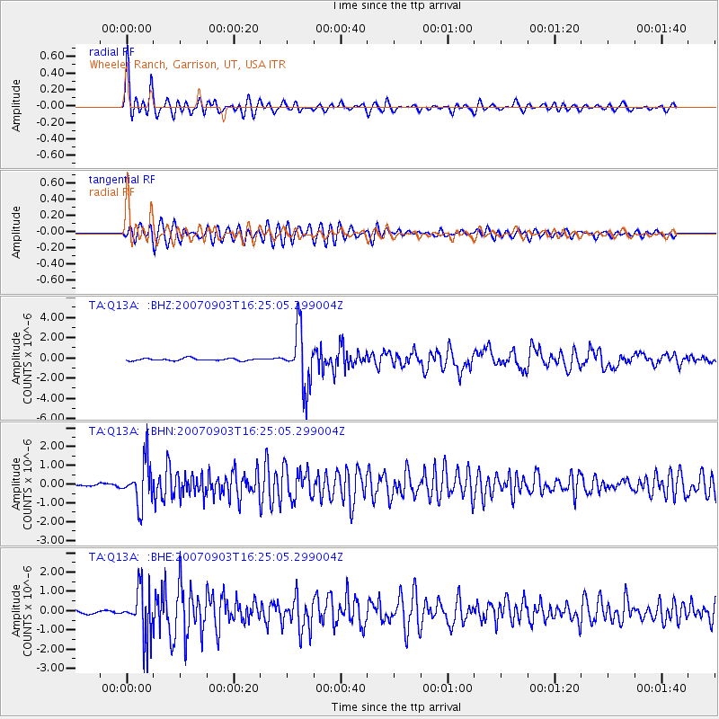
Signal To Noise
| Channel | StoN | STA | LTA |
| TA:Q13A: :BHN:20070903T16:25:05.299004Z | 12.291536 | 1.1541916E-6 | 9.3901335E-8 |
| TA:Q13A: :BHE:20070903T16:25:05.299004Z | 15.775671 | 1.2679843E-6 | 8.037594E-8 |
| TA:Q13A: :BHZ:20070903T16:25:05.299004Z | 23.909246 | 2.776755E-6 | 1.1613729E-7 |
| Arrivals |
| Ps | 1.7 SECOND |
| PpPs | 4.7 SECOND |
| PsPs/PpSs | 6.4 SECOND |


