You are here: Home > Network List > TA - USArray Transportable Network (new EarthScope stations) Stations List
> Station SUSD Miller, SD, USA > Earthquake Result Viewer
SUSD Miller, SD, USA - Earthquake Result Viewer
| Earthquake location: |
Dodecanese Islands, Greece |
| Earthquake latitude/longitude: |
36.9/27.5 |
| Earthquake time(UTC): |
2017/07/20 (201) 22:31:12 GMT |
| Earthquake Depth: |
10 km |
| Earthquake Magnitude: |
6.7 Mww |
| Earthquake Catalog/Contributor: |
NEIC PDE/us |
|
| Network: |
TA USArray Transportable Network (new EarthScope stations) |
| Station: |
SUSD Miller, SD, USA |
| Lat/Lon: |
44.44 N/98.96 W |
| Elevation: |
520 m |
|
| Distance: |
85.6 deg |
| Az: |
324.679 deg |
| Baz: |
40.287 deg |
| Ray Param: |
0.044660296 |
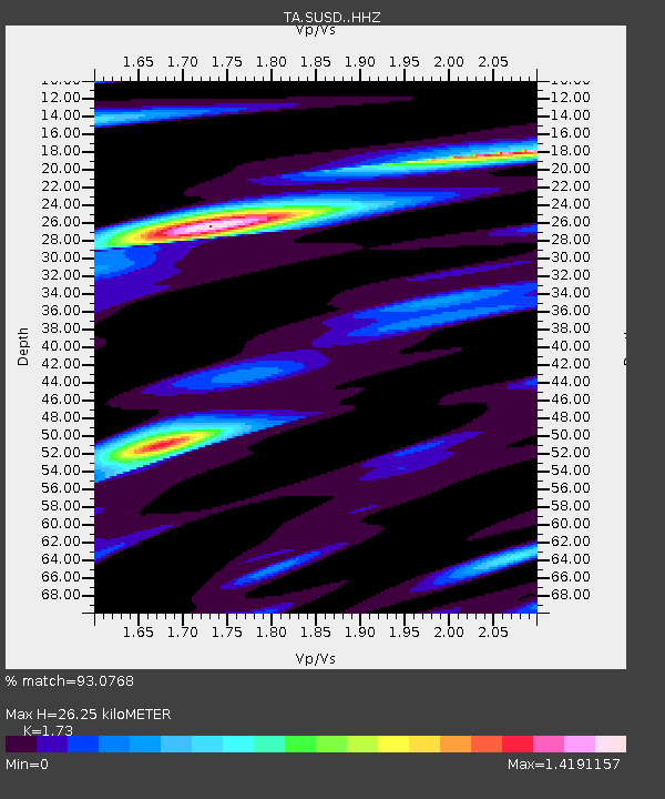
| Estimated Moho Depth: |
26.25 km |
| Estimated Crust Vp/Vs: |
1.73 |
| Assumed Crust Vp: |
6.53 km/s |
| Estimated Crust Vs: |
3.775 km/s |
| Estimated Crust Poisson's Ratio: |
0.25 |
|
| Radial Match: |
93.0768 % |
| Radial Bump: |
400 |
| Transverse Match: |
78.19189 % |
| Transverse Bump: |
400 |
| SOD ConfigId: |
13570011 |
| Insert Time: |
2019-04-28 10:47:53.873 +0000 |
| GWidth: |
2.5 |
| Max Bumps: |
400 |
| Tol: |
0.001 |
|

Signal To Noise
| Channel | StoN | STA | LTA |
| TA:SUSD: :HHZ:20170720T22:43:18.630017Z | 48.612373 | 4.28555E-6 | 8.81576E-8 |
| TA:SUSD: :HHN:20170720T22:43:18.630017Z | 8.679161 | 1.1228232E-6 | 1.2937001E-7 |
| TA:SUSD: :HHE:20170720T22:43:18.630017Z | 6.5265574 | 8.747614E-7 | 1.3403105E-7 |
| Arrivals |
| Ps | 3.0 SECOND |
| PpPs | 11 SECOND |
| PsPs/PpSs | 14 SECOND |


