You are here: Home > Network List > TA - USArray Transportable Network (new EarthScope stations) Stations List
> Station Q13A Wheeler Ranch, Garrison, UT, USA > Earthquake Result Viewer
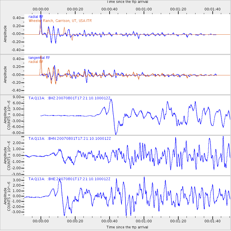
Q13A Wheeler Ranch, Garrison, UT, USA - Earthquake Result Viewer
| Earthquake location: |
Vanuatu Islands |
| Earthquake latitude/longitude: |
-15.6/167.7 |
| Earthquake time(UTC): |
2007/08/01 (213) 17:08:51 GMT |
| Earthquake Depth: |
120 km |
| Earthquake Magnitude: |
6.2 MB, 7.2 MW, 7.2 MW |
| Earthquake Catalog/Contributor: |
WHDF/NEIC |
|
| Network: |
TA USArray Transportable Network (new EarthScope stations) |
| Station: |
Q13A Wheeler Ranch, Garrison, UT, USA |
| Lat/Lon: |
38.96 N/114.02 W |
| Elevation: |
1583 m |
|
| Distance: |
90.9 deg |
| Az: |
49.781 deg |
| Baz: |
250.688 deg |
| Ray Param: |
0.041619428 |
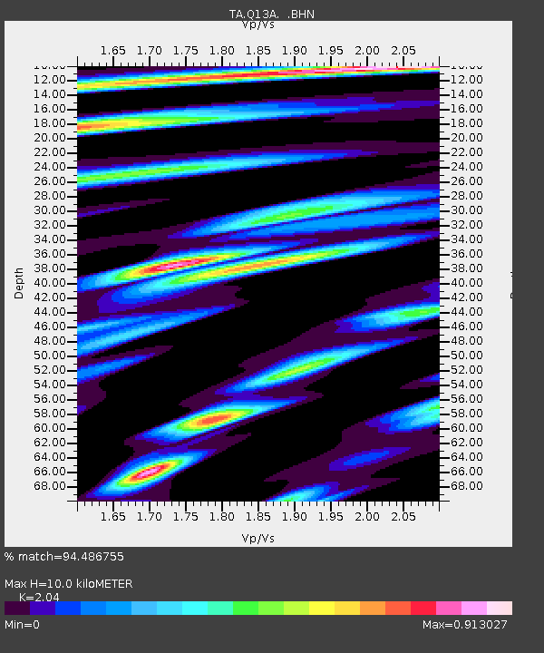
| Estimated Moho Depth: |
10.0 km |
| Estimated Crust Vp/Vs: |
2.04 |
| Assumed Crust Vp: |
6.276 km/s |
| Estimated Crust Vs: |
3.076 km/s |
| Estimated Crust Poisson's Ratio: |
0.34 |
|
| Radial Match: |
94.486755 % |
| Radial Bump: |
400 |
| Transverse Match: |
86.50786 % |
| Transverse Bump: |
400 |
| SOD ConfigId: |
2564 |
| Insert Time: |
2010-03-06 02:10:45.911 +0000 |
| GWidth: |
2.5 |
| Max Bumps: |
400 |
| Tol: |
0.001 |
|
Signal To Noise
| Channel | StoN | STA | LTA |
| TA:Q13A: :BHN:20070801T17:21:10.100012Z | 1.0418216 | 7.445102E-8 | 7.146236E-8 |
| TA:Q13A: :BHE:20070801T17:21:10.100012Z | 2.052856 | 1.305622E-7 | 6.360027E-8 |
| TA:Q13A: :BHZ:20070801T17:21:10.100012Z | 4.6539 | 4.7068144E-7 | 1.0113699E-7 |
| Arrivals |
| Ps | 1.7 SECOND |
| PpPs | 4.8 SECOND |
| PsPs/PpSs | 6.4 SECOND |


