You are here: Home > Network List > UO - University of Oregon Regional Network Stations List
> Station WLOO Lebanon, OR, USA > Earthquake Result Viewer
WLOO Lebanon, OR, USA - Earthquake Result Viewer
| Earthquake location: |
Dodecanese Islands, Greece |
| Earthquake latitude/longitude: |
36.9/27.5 |
| Earthquake time(UTC): |
2017/07/20 (201) 22:31:12 GMT |
| Earthquake Depth: |
10 km |
| Earthquake Magnitude: |
6.7 Mww |
| Earthquake Catalog/Contributor: |
NEIC PDE/us |
|
| Network: |
UO University of Oregon Regional Network |
| Station: |
WLOO Lebanon, OR, USA |
| Lat/Lon: |
44.52 N/122.74 W |
| Elevation: |
284 m |
|
| Distance: |
94.5 deg |
| Az: |
339.105 deg |
| Baz: |
23.543 deg |
| Ray Param: |
0.041021693 |
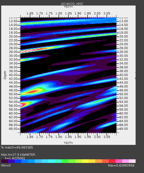
| Estimated Moho Depth: |
27.5 km |
| Estimated Crust Vp/Vs: |
1.62 |
| Assumed Crust Vp: |
6.566 km/s |
| Estimated Crust Vs: |
4.047 km/s |
| Estimated Crust Poisson's Ratio: |
0.19 |
|
| Radial Match: |
85.863365 % |
| Radial Bump: |
400 |
| Transverse Match: |
80.46063 % |
| Transverse Bump: |
400 |
| SOD ConfigId: |
13570011 |
| Insert Time: |
2019-04-28 10:48:34.969 +0000 |
| GWidth: |
2.5 |
| Max Bumps: |
400 |
| Tol: |
0.001 |
|

Signal To Noise
| Channel | StoN | STA | LTA |
| UO:WLOO: :HHZ:20170720T22:44:00.648022Z | 16.684326 | 1.2149175E-6 | 7.28179E-8 |
| UO:WLOO: :HHN:20170720T22:44:00.648022Z | 2.650879 | 3.148128E-7 | 1.187579E-7 |
| UO:WLOO: :HHE:20170720T22:44:00.648022Z | 3.4070995 | 2.7366607E-7 | 8.03223E-8 |
| Arrivals |
| Ps | 2.7 SECOND |
| PpPs | 11 SECOND |
| PsPs/PpSs | 13 SECOND |


