You are here: Home > Network List > UW - Pacific Northwest Regional Seismic Network Stations List
> Station MRBL Marblemount, WA, USA > Earthquake Result Viewer
MRBL Marblemount, WA, USA - Earthquake Result Viewer
| Earthquake location: |
Dodecanese Islands, Greece |
| Earthquake latitude/longitude: |
36.9/27.5 |
| Earthquake time(UTC): |
2017/07/20 (201) 22:31:12 GMT |
| Earthquake Depth: |
10 km |
| Earthquake Magnitude: |
6.7 Mww |
| Earthquake Catalog/Contributor: |
NEIC PDE/us |
|
| Network: |
UW Pacific Northwest Regional Seismic Network |
| Station: |
MRBL Marblemount, WA, USA |
| Lat/Lon: |
48.52 N/121.48 W |
| Elevation: |
75 m |
|
| Distance: |
90.5 deg |
| Az: |
339.939 deg |
| Baz: |
24.413 deg |
| Ray Param: |
0.041666944 |
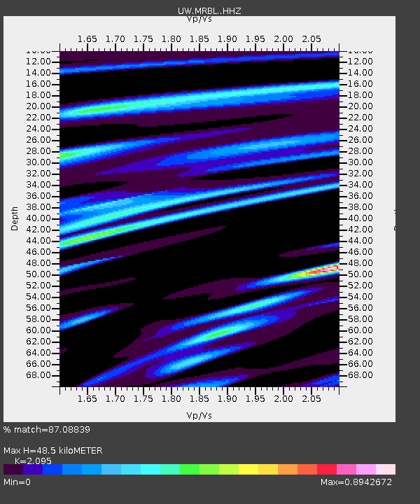
| Estimated Moho Depth: |
48.5 km |
| Estimated Crust Vp/Vs: |
2.10 |
| Assumed Crust Vp: |
6.566 km/s |
| Estimated Crust Vs: |
3.134 km/s |
| Estimated Crust Poisson's Ratio: |
0.35 |
|
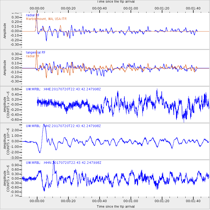
| Radial Match: |
87.08839 % |
| Radial Bump: |
400 |
| Transverse Match: |
79.69343 % |
| Transverse Bump: |
400 |
| SOD ConfigId: |
13570011 |
| Insert Time: |
2019-04-28 10:49:01.144 +0000 |
| GWidth: |
2.5 |
| Max Bumps: |
400 |
| Tol: |
0.001 |
|
Signal To Noise
| Channel | StoN | STA | LTA |
| UW:MRBL: :HHZ:20170720T22:43:42.247998Z | 38.35644 | 1.7003615E-6 | 4.4330534E-8 |
| UW:MRBL: :HHN:20170720T22:43:42.247998Z | 6.032726 | 4.3983403E-7 | 7.290801E-8 |
| UW:MRBL: :HHE:20170720T22:43:42.247998Z | 1.4195285 | 1.5033949E-7 | 1.0590804E-7 |
| Arrivals |
| Ps | 8.2 SECOND |
| PpPs | 22 SECOND |
| PsPs/PpSs | 31 SECOND |


