You are here: Home > Network List > TA - USArray Transportable Network (new EarthScope stations) Stations List
> Station Q13A Wheeler Ranch, Garrison, UT, USA > Earthquake Result Viewer
Q13A Wheeler Ranch, Garrison, UT, USA - Earthquake Result Viewer
| Earthquake location: |
Andreanof Islands, Aleutian Is. |
| Earthquake latitude/longitude: |
51.8/-176.3 |
| Earthquake time(UTC): |
2007/07/13 (194) 21:54:43 GMT |
| Earthquake Depth: |
35 km |
| Earthquake Magnitude: |
5.7 MB, 5.6 MS, 6.0 MW, 5.9 MW |
| Earthquake Catalog/Contributor: |
WHDF/NEIC |
|
| Network: |
TA USArray Transportable Network (new EarthScope stations) |
| Station: |
Q13A Wheeler Ranch, Garrison, UT, USA |
| Lat/Lon: |
38.96 N/114.02 W |
| Elevation: |
1583 m |
|
| Distance: |
44.3 deg |
| Az: |
81.439 deg |
| Baz: |
308.104 deg |
| Ray Param: |
0.071958914 |
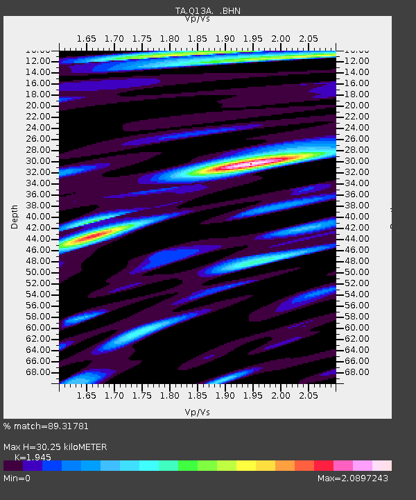
| Estimated Moho Depth: |
30.25 km |
| Estimated Crust Vp/Vs: |
1.95 |
| Assumed Crust Vp: |
6.276 km/s |
| Estimated Crust Vs: |
3.227 km/s |
| Estimated Crust Poisson's Ratio: |
0.32 |
|
| Radial Match: |
89.31781 % |
| Radial Bump: |
400 |
| Transverse Match: |
80.78633 % |
| Transverse Bump: |
400 |
| SOD ConfigId: |
2564 |
| Insert Time: |
2010-03-06 02:11:06.246 +0000 |
| GWidth: |
2.5 |
| Max Bumps: |
400 |
| Tol: |
0.001 |
|
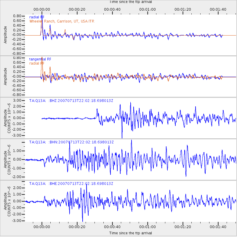
Signal To Noise
| Channel | StoN | STA | LTA |
| TA:Q13A: :BHN:20070713T22:02:18.698013Z | 4.948432 | 2.754123E-7 | 5.5656482E-8 |
| TA:Q13A: :BHE:20070713T22:02:18.698013Z | 4.5963063 | 3.1305646E-7 | 6.811044E-8 |
| TA:Q13A: :BHZ:20070713T22:02:18.698013Z | 14.937623 | 6.667027E-7 | 4.463245E-8 |
| Arrivals |
| Ps | 4.8 SECOND |
| PpPs | 13 SECOND |
| PsPs/PpSs | 18 SECOND |


