You are here: Home > Network List > YO16 - Yukon Observatory Stations List
> Station LIRD YGS, Liard River Highway Maintenance Camp, BC > Earthquake Result Viewer
LIRD YGS, Liard River Highway Maintenance Camp, BC - Earthquake Result Viewer
| Earthquake location: |
Dodecanese Islands, Greece |
| Earthquake latitude/longitude: |
36.9/27.5 |
| Earthquake time(UTC): |
2017/07/20 (201) 22:31:12 GMT |
| Earthquake Depth: |
10 km |
| Earthquake Magnitude: |
6.7 Mww |
| Earthquake Catalog/Contributor: |
NEIC PDE/us |
|
| Network: |
YO Yukon Observatory |
| Station: |
LIRD YGS, Liard River Highway Maintenance Camp, BC |
| Lat/Lon: |
59.41 N/126.10 W |
| Elevation: |
439 m |
|
| Distance: |
81.5 deg |
| Az: |
346.687 deg |
| Baz: |
21.143 deg |
| Ray Param: |
0.047529522 |
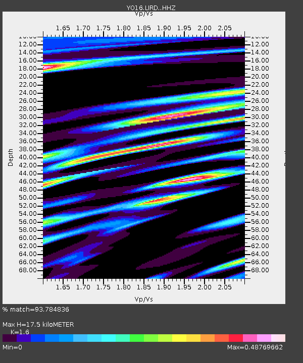
| Estimated Moho Depth: |
17.5 km |
| Estimated Crust Vp/Vs: |
1.60 |
| Assumed Crust Vp: |
6.419 km/s |
| Estimated Crust Vs: |
4.012 km/s |
| Estimated Crust Poisson's Ratio: |
0.18 |
|
| Radial Match: |
93.784836 % |
| Radial Bump: |
400 |
| Transverse Match: |
84.176704 % |
| Transverse Bump: |
400 |
| SOD ConfigId: |
13570011 |
| Insert Time: |
2019-04-28 10:49:59.975 +0000 |
| GWidth: |
2.5 |
| Max Bumps: |
400 |
| Tol: |
0.001 |
|

Signal To Noise
| Channel | StoN | STA | LTA |
| YO:LIRD: :HHZ:20170720T22:42:57.930005Z | 45.00489 | 2.8389945E-6 | 6.308191E-8 |
| YO:LIRD: :HHN:20170720T22:42:57.930005Z | 11.791864 | 1.0467671E-6 | 8.877028E-8 |
| YO:LIRD: :HHE:20170720T22:42:57.930005Z | 9.61854 | 5.757727E-7 | 5.986072E-8 |
| Arrivals |
| Ps | 1.7 SECOND |
| PpPs | 6.9 SECOND |
| PsPs/PpSs | 8.6 SECOND |


