You are here: Home > Network List > AV - Alaska Volcano Observatory Stations List
> Station MAPS Pakushin Southeast, Makushin Volcano, Alaska > Earthquake Result Viewer
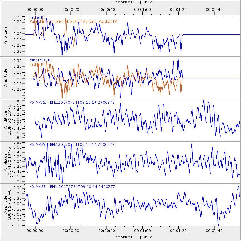
MAPS Pakushin Southeast, Makushin Volcano, Alaska - Earthquake Result Viewer
*The percent match for this event was below the threshold and hence no stack was calculated.
| Earthquake location: |
Vanuatu Islands |
| Earthquake latitude/longitude: |
-18.0/169.1 |
| Earthquake time(UTC): |
2017/07/21 (202) 08:59:08 GMT |
| Earthquake Depth: |
18 km |
| Earthquake Magnitude: |
5.5 Mww |
| Earthquake Catalog/Contributor: |
NEIC PDE/us |
|
| Network: |
AV Alaska Volcano Observatory |
| Station: |
MAPS Pakushin Southeast, Makushin Volcano, Alaska |
| Lat/Lon: |
53.81 N/166.94 W |
| Elevation: |
333 m |
|
| Distance: |
74.5 deg |
| Az: |
14.456 deg |
| Baz: |
203.609 deg |
| Ray Param: |
$rayparam |
*The percent match for this event was below the threshold and hence was not used in the summary stack. |
|
| Radial Match: |
58.495922 % |
| Radial Bump: |
312 |
| Transverse Match: |
45.463673 % |
| Transverse Bump: |
335 |
| SOD ConfigId: |
13570011 |
| Insert Time: |
2019-04-28 10:50:54.660 +0000 |
| GWidth: |
2.5 |
| Max Bumps: |
400 |
| Tol: |
0.001 |
|
Signal To Noise
| Channel | StoN | STA | LTA |
| AV:MAPS: :BHZ:20170721T09:10:14.240027Z | 1.1444677 | 2.6876066E-7 | 2.3483462E-7 |
| AV:MAPS: :BHN:20170721T09:10:14.240027Z | 2.5264418 | 9.298557E-7 | 3.6804948E-7 |
| AV:MAPS: :BHE:20170721T09:10:14.240027Z | 0.95133597 | 2.4966386E-7 | 2.62435E-7 |
| Arrivals |
| Ps | |
| PpPs | |
| PsPs/PpSs | |


