You are here: Home > Network List > TA - USArray Transportable Network (new EarthScope stations) Stations List
> Station J26L Joseph Creek, AK, USA > Earthquake Result Viewer
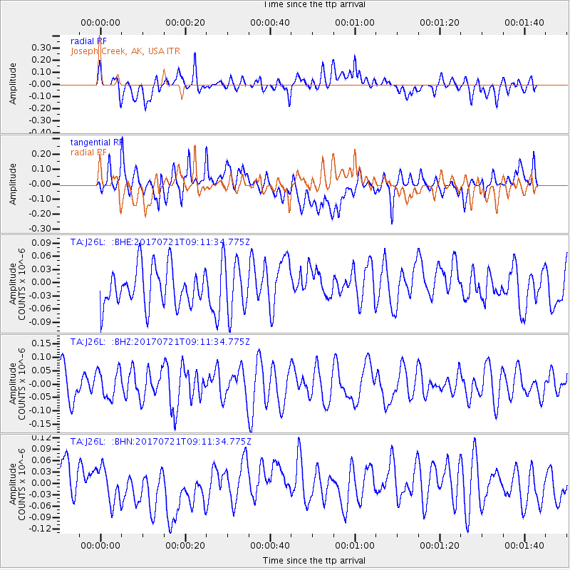
J26L Joseph Creek, AK, USA - Earthquake Result Viewer
*The percent match for this event was below the threshold and hence no stack was calculated.
| Earthquake location: |
Vanuatu Islands |
| Earthquake latitude/longitude: |
-18.0/169.1 |
| Earthquake time(UTC): |
2017/07/21 (202) 08:59:08 GMT |
| Earthquake Depth: |
18 km |
| Earthquake Magnitude: |
5.5 Mww |
| Earthquake Catalog/Contributor: |
NEIC PDE/us |
|
| Network: |
TA USArray Transportable Network (new EarthScope stations) |
| Station: |
J26L Joseph Creek, AK, USA |
| Lat/Lon: |
64.50 N/143.56 W |
| Elevation: |
1144 m |
|
| Distance: |
89.9 deg |
| Az: |
18.549 deg |
| Baz: |
224.368 deg |
| Ray Param: |
$rayparam |
*The percent match for this event was below the threshold and hence was not used in the summary stack. |
|
| Radial Match: |
47.805424 % |
| Radial Bump: |
400 |
| Transverse Match: |
50.225418 % |
| Transverse Bump: |
400 |
| SOD ConfigId: |
13570011 |
| Insert Time: |
2019-04-28 10:53:36.557 +0000 |
| GWidth: |
2.5 |
| Max Bumps: |
400 |
| Tol: |
0.001 |
|
Signal To Noise
| Channel | StoN | STA | LTA |
| TA:J26L: :BHZ:20170721T09:11:34.775Z | 0.9812722 | 5.2910064E-8 | 5.3919862E-8 |
| TA:J26L: :BHN:20170721T09:11:34.775Z | 1.1103208 | 6.272226E-8 | 5.649021E-8 |
| TA:J26L: :BHE:20170721T09:11:34.775Z | 1.3490162 | 5.7461303E-8 | 4.2594966E-8 |
| Arrivals |
| Ps | |
| PpPs | |
| PsPs/PpSs | |


