You are here: Home > Network List > GS - US Geological Survey Networks Stations List
> Station KAN11 Stewart Ranch, Harper County, KS, USA > Earthquake Result Viewer
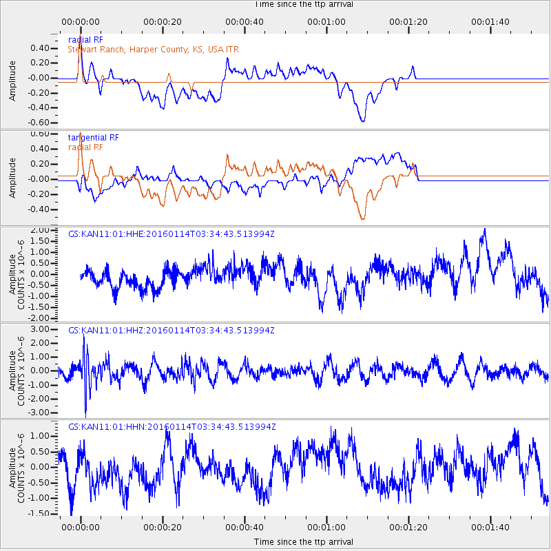
KAN11 Stewart Ranch, Harper County, KS, USA - Earthquake Result Viewer
*The percent match for this event was below the threshold and hence no stack was calculated.
| Earthquake location: |
Southern Bolivia |
| Earthquake latitude/longitude: |
-19.8/-63.3 |
| Earthquake time(UTC): |
2016/01/14 (014) 03:25:28 GMT |
| Earthquake Depth: |
582 km |
| Earthquake Magnitude: |
6.1 MWW, 6.1 MWB |
| Earthquake Catalog/Contributor: |
NEIC PDE/NEIC COMCAT |
|
| Network: |
GS US Geological Survey Networks |
| Station: |
KAN11 Stewart Ranch, Harper County, KS, USA |
| Lat/Lon: |
37.21 N/97.91 W |
| Elevation: |
410 m |
|
| Distance: |
65.4 deg |
| Az: |
330.08 deg |
| Baz: |
143.974 deg |
| Ray Param: |
$rayparam |
*The percent match for this event was below the threshold and hence was not used in the summary stack. |
|
| Radial Match: |
35.336 % |
| Radial Bump: |
400 |
| Transverse Match: |
34.338593 % |
| Transverse Bump: |
400 |
| SOD ConfigId: |
1399611 |
| Insert Time: |
2016-01-28 04:03:22.019 +0000 |
| GWidth: |
2.5 |
| Max Bumps: |
400 |
| Tol: |
0.001 |
|
Signal To Noise
| Channel | StoN | STA | LTA |
| GS:KAN11:01:HHZ:20160114T03:34:43.513994Z | 2.5917456 | 1.087249E-6 | 4.195045E-7 |
| GS:KAN11:01:HHN:20160114T03:34:43.513994Z | 1.3049048 | 6.3234927E-7 | 4.845942E-7 |
| GS:KAN11:01:HHE:20160114T03:34:43.513994Z | 1.439614 | 5.5929434E-7 | 3.8850297E-7 |
| Arrivals |
| Ps | |
| PpPs | |
| PsPs/PpSs | |


