You are here: Home > Network List > TA - USArray Transportable Network (new EarthScope stations) Stations List
> Station O28A Krutsinger Ranch, Parks, NE, USA > Earthquake Result Viewer
O28A Krutsinger Ranch, Parks, NE, USA - Earthquake Result Viewer
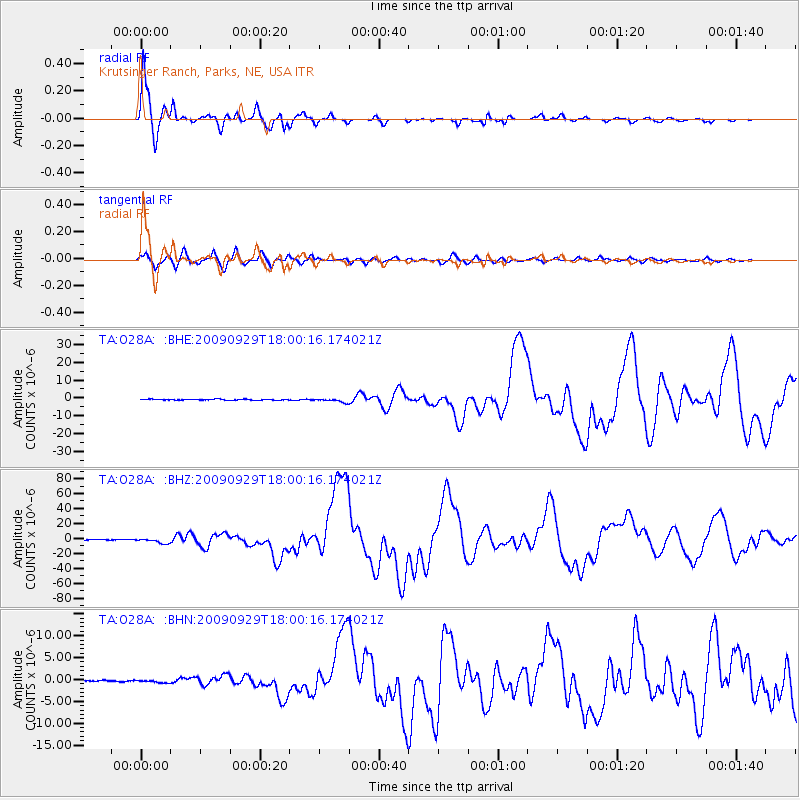
| Earthquake location: |
Samoa Islands Region |
| Earthquake latitude/longitude: |
-15.5/-172.1 |
| Earthquake time(UTC): |
2009/09/29 (272) 17:48:10 GMT |
| Earthquake Depth: |
18 km |
| Earthquake Magnitude: |
7.1 MB, 8.1 MS, 8.1 MW, 8.0 MW |
| Earthquake Catalog/Contributor: |
WHDF/NEIC |
|
| Network: |
TA USArray Transportable Network (new EarthScope stations) |
| Station: |
O28A Krutsinger Ranch, Parks, NE, USA |
| Lat/Lon: |
40.13 N/101.77 W |
| Elevation: |
1032 m |
|
| Distance: |
85.5 deg |
| Az: |
46.403 deg |
| Baz: |
245.595 deg |
| Ray Param: |
0.04471064 |
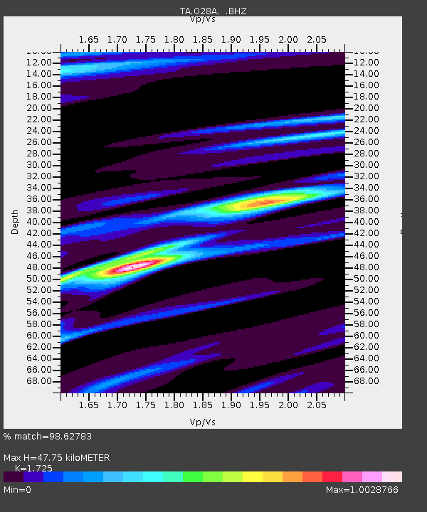
| Estimated Moho Depth: |
47.75 km |
| Estimated Crust Vp/Vs: |
1.73 |
| Assumed Crust Vp: |
6.483 km/s |
| Estimated Crust Vs: |
3.758 km/s |
| Estimated Crust Poisson's Ratio: |
0.25 |
|
| Radial Match: |
98.62783 % |
| Radial Bump: |
358 |
| Transverse Match: |
92.97437 % |
| Transverse Bump: |
400 |
| SOD ConfigId: |
2622 |
| Insert Time: |
2010-03-06 02:12:16.009 +0000 |
| GWidth: |
2.5 |
| Max Bumps: |
400 |
| Tol: |
0.001 |
|
Signal To Noise
| Channel | StoN | STA | LTA |
| TA:O28A: :BHZ:20090929T18:00:16.174021Z | 12.245774 | 3.0345745E-6 | 2.4780587E-7 |
| TA:O28A: :BHN:20090929T18:00:16.174021Z | 1.4153099 | 2.6765426E-7 | 1.8911352E-7 |
| TA:O28A: :BHE:20090929T18:00:16.174021Z | 4.0638824 | 9.823722E-7 | 2.4173244E-7 |
| Arrivals |
| Ps | 5.5 SECOND |
| PpPs | 20 SECOND |
| PsPs/PpSs | 25 SECOND |


