You are here: Home > Network List > TA - USArray Transportable Network (new EarthScope stations) Stations List
> Station L28A Connealy Angus Ranch, Whitman, NE, USA > Earthquake Result Viewer
L28A Connealy Angus Ranch, Whitman, NE, USA - Earthquake Result Viewer
| Earthquake location: |
Norwegian Sea |
| Earthquake latitude/longitude: |
72.2/0.9 |
| Earthquake time(UTC): |
2009/08/20 (232) 06:35:04 GMT |
| Earthquake Depth: |
6.0 km |
| Earthquake Magnitude: |
5.9 MB, 5.7 MS, 6.0 MW, 6.0 MW |
| Earthquake Catalog/Contributor: |
WHDF/NEIC |
|
| Network: |
TA USArray Transportable Network (new EarthScope stations) |
| Station: |
L28A Connealy Angus Ranch, Whitman, NE, USA |
| Lat/Lon: |
42.01 N/101.52 W |
| Elevation: |
1155 m |
|
| Distance: |
54.2 deg |
| Az: |
296.202 deg |
| Baz: |
21.732 deg |
| Ray Param: |
0.06560554 |
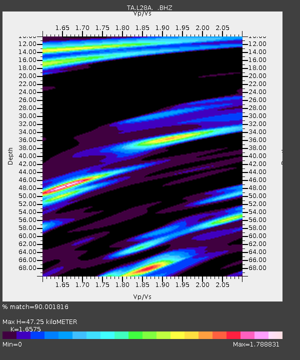
| Estimated Moho Depth: |
47.25 km |
| Estimated Crust Vp/Vs: |
1.66 |
| Assumed Crust Vp: |
6.483 km/s |
| Estimated Crust Vs: |
3.911 km/s |
| Estimated Crust Poisson's Ratio: |
0.21 |
|
| Radial Match: |
90.001816 % |
| Radial Bump: |
400 |
| Transverse Match: |
69.44038 % |
| Transverse Bump: |
400 |
| SOD ConfigId: |
2622 |
| Insert Time: |
2010-03-06 02:12:50.316 +0000 |
| GWidth: |
2.5 |
| Max Bumps: |
400 |
| Tol: |
0.001 |
|

Signal To Noise
| Channel | StoN | STA | LTA |
| TA:L28A: :BHZ:20090820T06:43:59.648994Z | 25.606455 | 2.3320304E-6 | 9.1071975E-8 |
| TA:L28A: :BHN:20090820T06:43:59.648994Z | 3.662837 | 8.8801426E-7 | 2.4243892E-7 |
| TA:L28A: :BHE:20090820T06:43:59.648994Z | 1.5290443 | 4.55463E-7 | 2.9787432E-7 |
| Arrivals |
| Ps | 5.1 SECOND |
| PpPs | 18 SECOND |
| PsPs/PpSs | 23 SECOND |


