You are here: Home > Network List > TA - USArray Transportable Network (new EarthScope stations) Stations List
> Station L28A Connealy Angus Ranch, Whitman, NE, USA > Earthquake Result Viewer
L28A Connealy Angus Ranch, Whitman, NE, USA - Earthquake Result Viewer
| Earthquake location: |
Northern Mid-Atlantic Ridge |
| Earthquake latitude/longitude: |
23.9/-46.1 |
| Earthquake time(UTC): |
2009/06/06 (157) 20:33:28 GMT |
| Earthquake Depth: |
14 km |
| Earthquake Magnitude: |
6.0 MB, 5.7 MS, 6.0 MW, 6.0 MW |
| Earthquake Catalog/Contributor: |
WHDF/NEIC |
|
| Network: |
TA USArray Transportable Network (new EarthScope stations) |
| Station: |
L28A Connealy Angus Ranch, Whitman, NE, USA |
| Lat/Lon: |
42.01 N/101.52 W |
| Elevation: |
1155 m |
|
| Distance: |
49.0 deg |
| Az: |
305.657 deg |
| Baz: |
93.542 deg |
| Ray Param: |
0.068949275 |
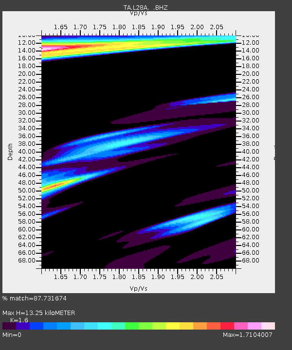
| Estimated Moho Depth: |
13.25 km |
| Estimated Crust Vp/Vs: |
1.60 |
| Assumed Crust Vp: |
6.483 km/s |
| Estimated Crust Vs: |
4.052 km/s |
| Estimated Crust Poisson's Ratio: |
0.18 |
|
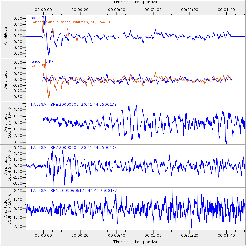
| Radial Match: |
87.731674 % |
| Radial Bump: |
400 |
| Transverse Match: |
63.263203 % |
| Transverse Bump: |
400 |
| SOD ConfigId: |
2648 |
| Insert Time: |
2010-03-06 02:12:54.535 +0000 |
| GWidth: |
2.5 |
| Max Bumps: |
400 |
| Tol: |
0.001 |
|
Signal To Noise
| Channel | StoN | STA | LTA |
| TA:L28A: :BHZ:20090606T20:41:44.250013Z | 7.491178 | 1.1357736E-6 | 1.5161481E-7 |
| TA:L28A: :BHN:20090606T20:41:44.250013Z | 1.0037909 | 3.3350426E-7 | 3.3224478E-7 |
| TA:L28A: :BHE:20090606T20:41:44.250013Z | 1.3793111 | 5.7771246E-7 | 4.1884132E-7 |
| Arrivals |
| Ps | 1.3 SECOND |
| PpPs | 5.0 SECOND |
| PsPs/PpSs | 6.3 SECOND |


