You are here: Home > Network List > AV - Alaska Volcano Observatory Stations List
> Station AMKA Regional Station, Amchitka Island, Alaska > Earthquake Result Viewer
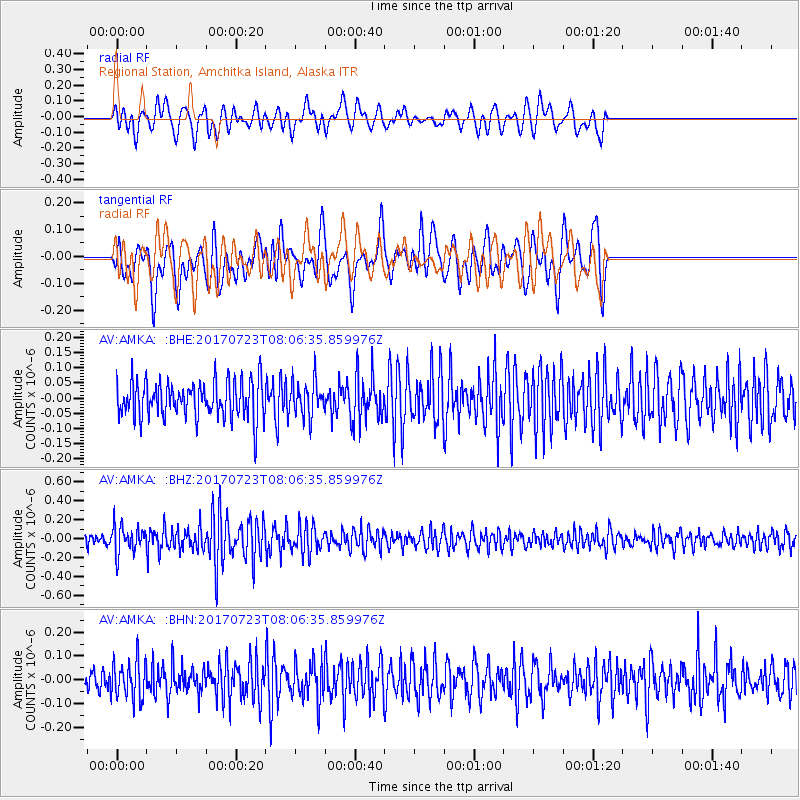
AMKA Regional Station, Amchitka Island, Alaska - Earthquake Result Viewer
*The percent match for this event was below the threshold and hence no stack was calculated.
| Earthquake location: |
Minahassa Peninsula, Sulawesi |
| Earthquake latitude/longitude: |
0.3/120.2 |
| Earthquake time(UTC): |
2017/07/23 (204) 07:55:55 GMT |
| Earthquake Depth: |
56 km |
| Earthquake Magnitude: |
5.5 Mww |
| Earthquake Catalog/Contributor: |
NEIC PDE/us |
|
| Network: |
AV Alaska Volcano Observatory |
| Station: |
AMKA Regional Station, Amchitka Island, Alaska |
| Lat/Lon: |
51.38 N/179.30 E |
| Elevation: |
116 m |
|
| Distance: |
71.0 deg |
| Az: |
34.668 deg |
| Baz: |
245.174 deg |
| Ray Param: |
$rayparam |
*The percent match for this event was below the threshold and hence was not used in the summary stack. |
|
| Radial Match: |
53.329956 % |
| Radial Bump: |
400 |
| Transverse Match: |
60.447693 % |
| Transverse Bump: |
400 |
| SOD ConfigId: |
13570011 |
| Insert Time: |
2019-04-28 11:05:19.702 +0000 |
| GWidth: |
2.5 |
| Max Bumps: |
400 |
| Tol: |
0.001 |
|
Signal To Noise
| Channel | StoN | STA | LTA |
| AV:AMKA: :BHZ:20170723T08:06:35.859976Z | 1.910313 | 1.4587444E-7 | 7.636154E-8 |
| AV:AMKA: :BHN:20170723T08:06:35.859976Z | 1.3324276 | 8.319335E-8 | 6.243742E-8 |
| AV:AMKA: :BHE:20170723T08:06:35.859976Z | 0.90925753 | 5.5383037E-8 | 6.091018E-8 |
| Arrivals |
| Ps | |
| PpPs | |
| PsPs/PpSs | |


