You are here: Home > Network List > TA - USArray Transportable Network (new EarthScope stations) Stations List
> Station I17K Unalakleet, AK, USA > Earthquake Result Viewer
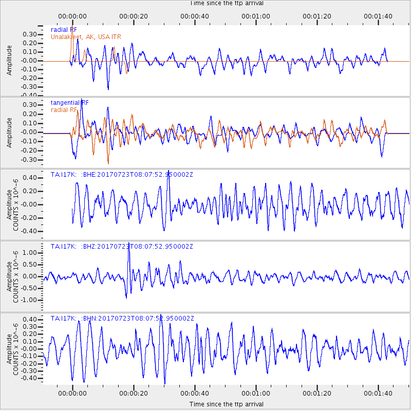
I17K Unalakleet, AK, USA - Earthquake Result Viewer
*The percent match for this event was below the threshold and hence no stack was calculated.
| Earthquake location: |
Minahassa Peninsula, Sulawesi |
| Earthquake latitude/longitude: |
0.3/120.2 |
| Earthquake time(UTC): |
2017/07/23 (204) 07:55:55 GMT |
| Earthquake Depth: |
56 km |
| Earthquake Magnitude: |
5.5 Mww |
| Earthquake Catalog/Contributor: |
NEIC PDE/us |
|
| Network: |
TA USArray Transportable Network (new EarthScope stations) |
| Station: |
I17K Unalakleet, AK, USA |
| Lat/Lon: |
63.89 N/160.70 W |
| Elevation: |
105 m |
|
| Distance: |
84.9 deg |
| Az: |
25.866 deg |
| Baz: |
260.335 deg |
| Ray Param: |
$rayparam |
*The percent match for this event was below the threshold and hence was not used in the summary stack. |
|
| Radial Match: |
56.856308 % |
| Radial Bump: |
400 |
| Transverse Match: |
61.857227 % |
| Transverse Bump: |
400 |
| SOD ConfigId: |
13570011 |
| Insert Time: |
2019-04-28 11:06:54.155 +0000 |
| GWidth: |
2.5 |
| Max Bumps: |
400 |
| Tol: |
0.001 |
|
Signal To Noise
| Channel | StoN | STA | LTA |
| TA:I17K: :BHZ:20170723T08:07:52.950002Z | 1.2784508 | 1.2022191E-7 | 9.403718E-8 |
| TA:I17K: :BHN:20170723T08:07:52.950002Z | 2.501142 | 2.7239935E-7 | 1.0890999E-7 |
| TA:I17K: :BHE:20170723T08:07:52.950002Z | 1.4727566 | 2.3487785E-7 | 1.5948177E-7 |
| Arrivals |
| Ps | |
| PpPs | |
| PsPs/PpSs | |


