You are here: Home > Network List > CN - Canadian National Seismograph Network Stations List
> Station INK INUVIK, NT > Earthquake Result Viewer
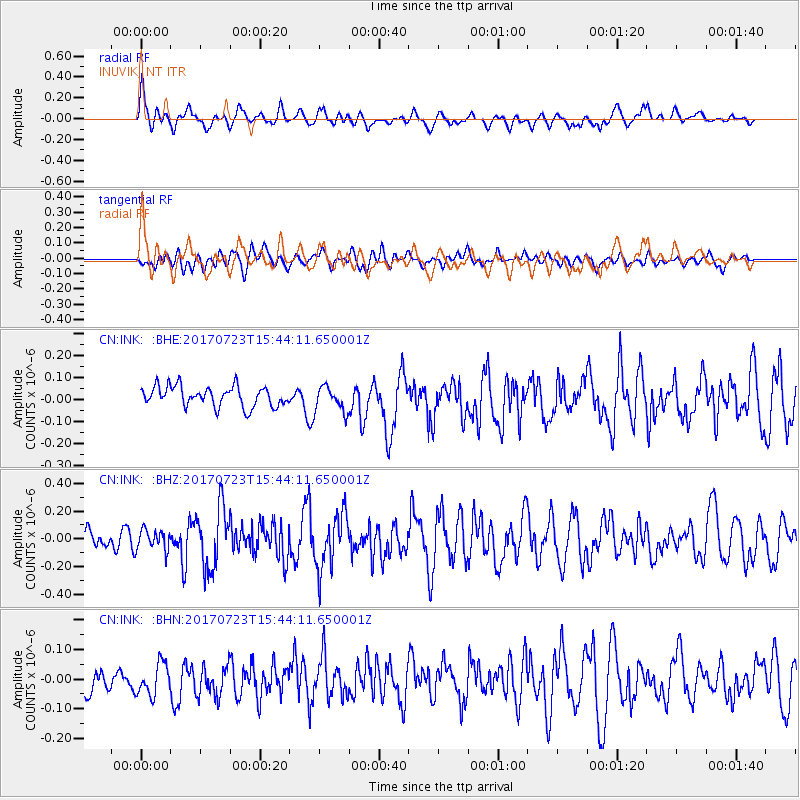
INK INUVIK, NT - Earthquake Result Viewer
*The percent match for this event was below the threshold and hence no stack was calculated.
| Earthquake location: |
Off East Coast Of Honshu, Japan |
| Earthquake latitude/longitude: |
40.0/143.5 |
| Earthquake time(UTC): |
2017/07/23 (204) 15:35:40 GMT |
| Earthquake Depth: |
10 km |
| Earthquake Magnitude: |
5.6 Mww |
| Earthquake Catalog/Contributor: |
NEIC PDE/us |
|
| Network: |
CN Canadian National Seismograph Network |
| Station: |
INK INUVIK, NT |
| Lat/Lon: |
68.31 N/133.53 W |
| Elevation: |
44 m |
|
| Distance: |
51.0 deg |
| Az: |
28.362 deg |
| Baz: |
281.234 deg |
| Ray Param: |
$rayparam |
*The percent match for this event was below the threshold and hence was not used in the summary stack. |
|
| Radial Match: |
62.986526 % |
| Radial Bump: |
400 |
| Transverse Match: |
52.272877 % |
| Transverse Bump: |
400 |
| SOD ConfigId: |
13570011 |
| Insert Time: |
2019-04-28 11:10:11.066 +0000 |
| GWidth: |
2.5 |
| Max Bumps: |
400 |
| Tol: |
0.001 |
|
Signal To Noise
| Channel | StoN | STA | LTA |
| CN:INK: :BHZ:20170723T15:44:11.650001Z | 1.0134133 | 7.1222246E-8 | 7.027956E-8 |
| CN:INK: :BHN:20170723T15:44:11.650001Z | 1.1343071 | 5.2403475E-8 | 4.6198664E-8 |
| CN:INK: :BHE:20170723T15:44:11.650001Z | 1.2785997 | 5.857173E-8 | 4.5809276E-8 |
| Arrivals |
| Ps | |
| PpPs | |
| PsPs/PpSs | |


