You are here: Home > Network List > TA - USArray Transportable Network (new EarthScope stations) Stations List
> Station X16A Lo Mia Camp, Pine, AZ, USA > Earthquake Result Viewer
X16A Lo Mia Camp, Pine, AZ, USA - Earthquake Result Viewer

| Earthquake location: |
Volcano Islands, Japan Region |
| Earthquake latitude/longitude: |
22.0/142.7 |
| Earthquake time(UTC): |
2007/09/28 (271) 13:38:59 GMT |
| Earthquake Depth: |
276 km |
| Earthquake Magnitude: |
6.7 MB, 7.4 MW, 7.4 MW |
| Earthquake Catalog/Contributor: |
WHDF/NEIC |
|
| Network: |
TA USArray Transportable Network (new EarthScope stations) |
| Station: |
X16A Lo Mia Camp, Pine, AZ, USA |
| Lat/Lon: |
34.42 N/111.44 W |
| Elevation: |
1759 m |
|
| Distance: |
90.0 deg |
| Az: |
52.659 deg |
| Baz: |
296.813 deg |
| Ray Param: |
0.041638184 |
| Estimated Moho Depth: |
34.0 km |
| Estimated Crust Vp/Vs: |
1.95 |
| Assumed Crust Vp: |
6.207 km/s |
| Estimated Crust Vs: |
3.191 km/s |
| Estimated Crust Poisson's Ratio: |
0.32 |
|
| Radial Match: |
96.05748 % |
| Radial Bump: |
400 |
| Transverse Match: |
84.3713 % |
| Transverse Bump: |
400 |
| SOD ConfigId: |
2564 |
| Insert Time: |
2010-03-06 02:13:46.988 +0000 |
| GWidth: |
2.5 |
| Max Bumps: |
400 |
| Tol: |
0.001 |
|
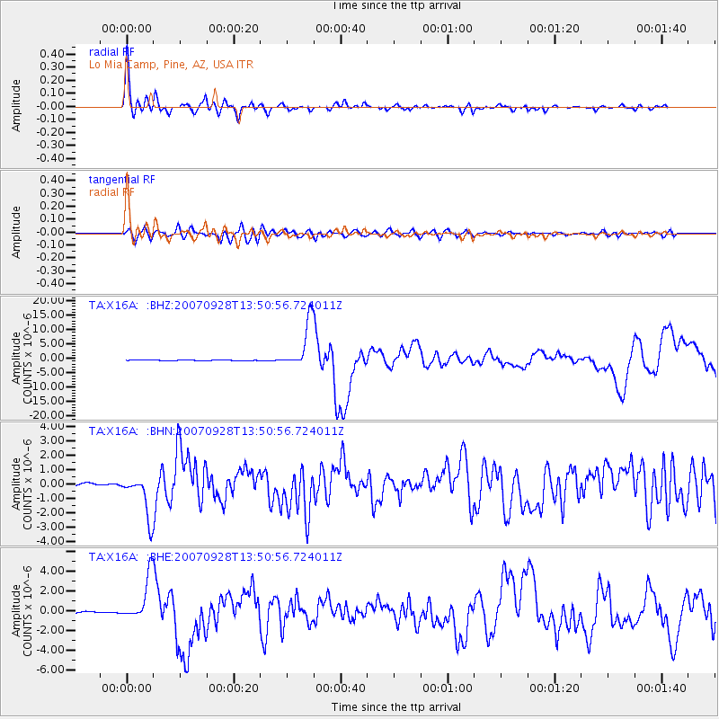
Signal To Noise
| Channel | StoN | STA | LTA |
| TA:X16A: :BHN:20070928T13:50:56.724011Z | 14.51863 | 1.4790058E-6 | 1.0186951E-7 |
| TA:X16A: :BHE:20070928T13:50:56.724011Z | 19.587797 | 2.289426E-6 | 1.1688023E-7 |
| TA:X16A: :BHZ:20070928T13:50:56.724011Z | 59.92492 | 8.36389E-6 | 1.3957282E-7 |
| Arrivals |
| Ps | 5.3 SECOND |
| PpPs | 16 SECOND |
| PsPs/PpSs | 21 SECOND |


