You are here: Home > Network List > TA - USArray Transportable Network (new EarthScope stations) Stations List
> Station X16A Lo Mia Camp, Pine, AZ, USA > Earthquake Result Viewer
X16A Lo Mia Camp, Pine, AZ, USA - Earthquake Result Viewer
| Earthquake location: |
Southeast Of Loyalty Islands |
| Earthquake latitude/longitude: |
-21.1/169.4 |
| Earthquake time(UTC): |
2007/09/28 (271) 01:35:51 GMT |
| Earthquake Depth: |
10 km |
| Earthquake Magnitude: |
6.1 MB, 6.6 MS, 6.5 MW, 6.3 MW |
| Earthquake Catalog/Contributor: |
WHDF/NEIC |
|
| Network: |
TA USArray Transportable Network (new EarthScope stations) |
| Station: |
X16A Lo Mia Camp, Pine, AZ, USA |
| Lat/Lon: |
34.42 N/111.44 W |
| Elevation: |
1759 m |
|
| Distance: |
93.3 deg |
| Az: |
54.423 deg |
| Baz: |
246.702 deg |
| Ray Param: |
0.04129594 |
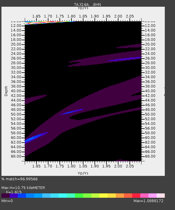
| Estimated Moho Depth: |
10.75 km |
| Estimated Crust Vp/Vs: |
1.62 |
| Assumed Crust Vp: |
6.207 km/s |
| Estimated Crust Vs: |
3.843 km/s |
| Estimated Crust Poisson's Ratio: |
0.19 |
|
| Radial Match: |
96.99566 % |
| Radial Bump: |
306 |
| Transverse Match: |
94.01517 % |
| Transverse Bump: |
307 |
| SOD ConfigId: |
2564 |
| Insert Time: |
2010-03-06 02:13:48.476 +0000 |
| GWidth: |
2.5 |
| Max Bumps: |
400 |
| Tol: |
0.001 |
|
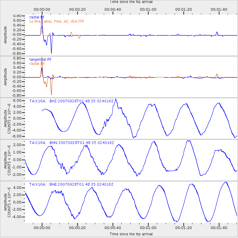
Signal To Noise
| Channel | StoN | STA | LTA |
| TA:X16A: :BHN:20070928T01:48:35.024016Z | 1.3694824 | 1.3873589E-6 | 1.0130535E-6 |
| TA:X16A: :BHE:20070928T01:48:35.024016Z | 1.3694986 | 2.4818469E-6 | 1.8122302E-6 |
| TA:X16A: :BHZ:20070928T01:48:35.024016Z | 1.5445801 | 5.108324E-6 | 3.3072572E-6 |
| Arrivals |
| Ps | 1.1 SECOND |
| PpPs | 4.4 SECOND |
| PsPs/PpSs | 5.5 SECOND |


