You are here: Home > Network List > TA - USArray Transportable Network (new EarthScope stations) Stations List
> Station X16A Lo Mia Camp, Pine, AZ, USA > Earthquake Result Viewer
X16A Lo Mia Camp, Pine, AZ, USA - Earthquake Result Viewer

| Earthquake location: |
Andreanof Islands, Aleutian Is. |
| Earthquake latitude/longitude: |
51.8/-176.3 |
| Earthquake time(UTC): |
2007/07/13 (194) 21:54:43 GMT |
| Earthquake Depth: |
35 km |
| Earthquake Magnitude: |
5.7 MB, 5.6 MS, 6.0 MW, 5.9 MW |
| Earthquake Catalog/Contributor: |
WHDF/NEIC |
|
| Network: |
TA USArray Transportable Network (new EarthScope stations) |
| Station: |
X16A Lo Mia Camp, Pine, AZ, USA |
| Lat/Lon: |
34.42 N/111.44 W |
| Elevation: |
1759 m |
|
| Distance: |
48.8 deg |
| Az: |
84.394 deg |
| Baz: |
311.675 deg |
| Ray Param: |
0.06908039 |
| Estimated Moho Depth: |
56.0 km |
| Estimated Crust Vp/Vs: |
2.09 |
| Assumed Crust Vp: |
6.207 km/s |
| Estimated Crust Vs: |
2.97 km/s |
| Estimated Crust Poisson's Ratio: |
0.35 |
|
| Radial Match: |
83.14315 % |
| Radial Bump: |
400 |
| Transverse Match: |
66.81823 % |
| Transverse Bump: |
400 |
| SOD ConfigId: |
2564 |
| Insert Time: |
2010-03-06 02:14:27.697 +0000 |
| GWidth: |
2.5 |
| Max Bumps: |
400 |
| Tol: |
0.001 |
|
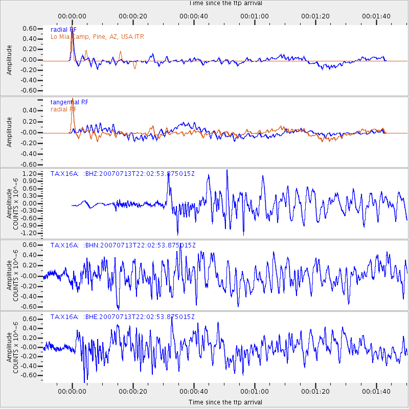
Signal To Noise
| Channel | StoN | STA | LTA |
| TA:X16A: :BHN:20070713T22:02:53.875015Z | 1.619335 | 1.4396828E-7 | 8.890581E-8 |
| TA:X16A: :BHE:20070713T22:02:53.875015Z | 4.027623 | 2.2914779E-7 | 5.689405E-8 |
| TA:X16A: :BHZ:20070713T22:02:53.875015Z | 7.829159 | 5.090918E-7 | 6.50251E-8 |
| Arrivals |
| Ps | 10 SECOND |
| PpPs | 27 SECOND |
| PsPs/PpSs | 37 SECOND |


