You are here: Home > Network List > KR - Kyrgyz Digital Network Stations List
> Station ARLS Aral, Kyrgyzstan > Earthquake Result Viewer
ARLS Aral, Kyrgyzstan - Earthquake Result Viewer
| Earthquake location: |
Southwest Of Sumatra, Indonesia |
| Earthquake latitude/longitude: |
-5.7/101.4 |
| Earthquake time(UTC): |
2017/07/25 (206) 23:23:23 GMT |
| Earthquake Depth: |
10 km |
| Earthquake Magnitude: |
5.5 mb |
| Earthquake Catalog/Contributor: |
NEIC PDE/us |
|
| Network: |
KR Kyrgyz Digital Network |
| Station: |
ARLS Aral, Kyrgyzstan |
| Lat/Lon: |
41.87 N/74.33 E |
| Elevation: |
1526 m |
|
| Distance: |
53.4 deg |
| Az: |
334.936 deg |
| Baz: |
145.635 deg |
| Ray Param: |
0.066141024 |
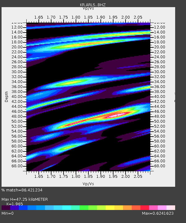
| Estimated Moho Depth: |
47.25 km |
| Estimated Crust Vp/Vs: |
1.97 |
| Assumed Crust Vp: |
6.491 km/s |
| Estimated Crust Vs: |
3.303 km/s |
| Estimated Crust Poisson's Ratio: |
0.33 |
|
| Radial Match: |
86.421234 % |
| Radial Bump: |
326 |
| Transverse Match: |
37.10763 % |
| Transverse Bump: |
400 |
| SOD ConfigId: |
13570011 |
| Insert Time: |
2019-04-28 11:18:06.975 +0000 |
| GWidth: |
2.5 |
| Max Bumps: |
400 |
| Tol: |
0.001 |
|

Signal To Noise
| Channel | StoN | STA | LTA |
| KR:ARLS: :BHZ:20170725T23:32:11.739978Z | 4.085559 | 1.8720321E-7 | 4.582071E-8 |
| KR:ARLS: :BHN:20170725T23:32:11.739978Z | 1.7557939 | 1.330108E-7 | 7.575536E-8 |
| KR:ARLS: :BHE:20170725T23:32:11.739978Z | 0.60245967 | 4.8136275E-8 | 7.989958E-8 |
| Arrivals |
| Ps | 7.4 SECOND |
| PpPs | 21 SECOND |
| PsPs/PpSs | 28 SECOND |


