You are here: Home > Network List > US - United States National Seismic Network Stations List
> Station ERPA Erie, Pennsylvania, USA > Earthquake Result Viewer
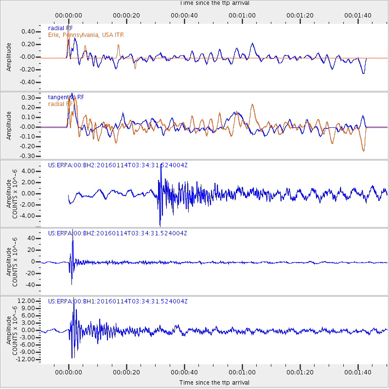
ERPA Erie, Pennsylvania, USA - Earthquake Result Viewer
*The percent match for this event was below the threshold and hence no stack was calculated.
| Earthquake location: |
Southern Bolivia |
| Earthquake latitude/longitude: |
-19.8/-63.3 |
| Earthquake time(UTC): |
2016/01/14 (014) 03:25:28 GMT |
| Earthquake Depth: |
582 km |
| Earthquake Magnitude: |
6.1 MWW, 6.1 MWB |
| Earthquake Catalog/Contributor: |
NEIC PDE/NEIC COMCAT |
|
| Network: |
US United States National Seismic Network |
| Station: |
ERPA Erie, Pennsylvania, USA |
| Lat/Lon: |
42.12 N/79.99 W |
| Elevation: |
306 m |
|
| Distance: |
63.5 deg |
| Az: |
346.18 deg |
| Baz: |
162.406 deg |
| Ray Param: |
$rayparam |
*The percent match for this event was below the threshold and hence was not used in the summary stack. |
|
| Radial Match: |
42.610798 % |
| Radial Bump: |
400 |
| Transverse Match: |
58.672386 % |
| Transverse Bump: |
400 |
| SOD ConfigId: |
1399611 |
| Insert Time: |
2016-01-28 04:11:43.454 +0000 |
| GWidth: |
2.5 |
| Max Bumps: |
400 |
| Tol: |
0.001 |
|
Signal To Noise
| Channel | StoN | STA | LTA |
| US:ERPA:00:BHZ:20160114T03:34:31.524004Z | 24.698545 | 1.2163581E-5 | 4.9248166E-7 |
| US:ERPA:00:BH1:20160114T03:34:31.524004Z | 10.965016 | 4.422492E-6 | 4.0332742E-7 |
| US:ERPA:00:BH2:20160114T03:34:31.524004Z | 3.2264993 | 1.8191802E-6 | 5.6382476E-7 |
| Arrivals |
| Ps | |
| PpPs | |
| PsPs/PpSs | |


