You are here: Home > Network List > AK - Alaska Regional Network Stations List
> Station CUT Chulitna, AK, USA > Earthquake Result Viewer
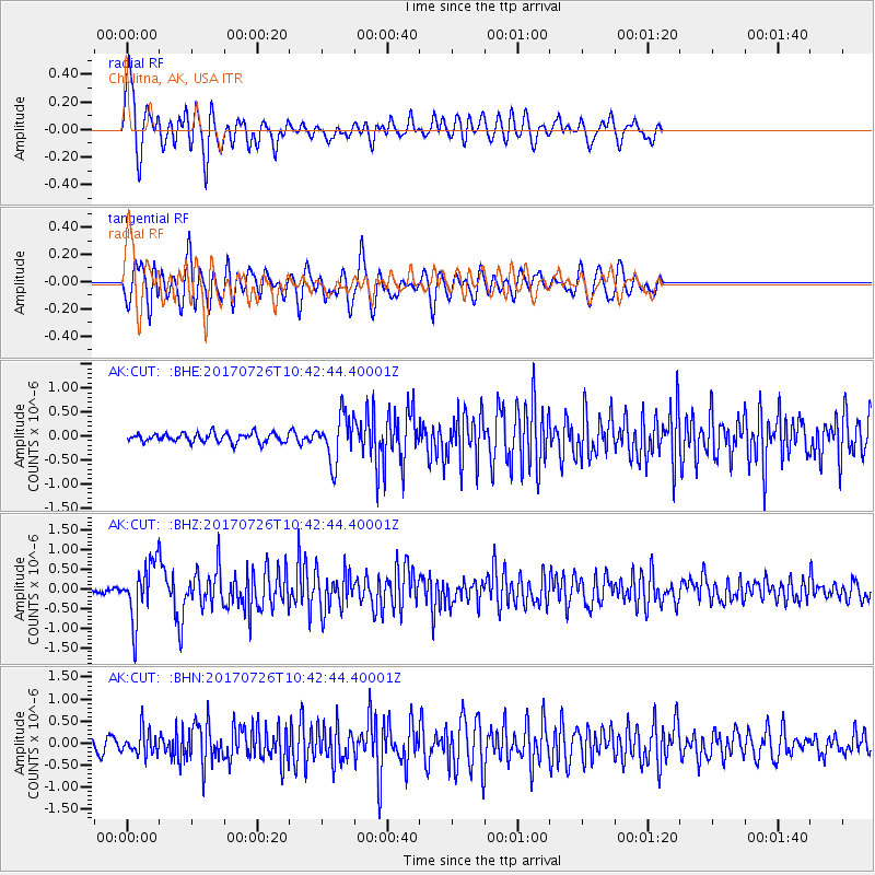
CUT Chulitna, AK, USA - Earthquake Result Viewer
*The percent match for this event was below the threshold and hence no stack was calculated.
| Earthquake location: |
Southeast Of Ryukyu Islands |
| Earthquake latitude/longitude: |
26.9/130.2 |
| Earthquake time(UTC): |
2017/07/26 (207) 10:32:57 GMT |
| Earthquake Depth: |
10 km |
| Earthquake Magnitude: |
5.9 Mww |
| Earthquake Catalog/Contributor: |
NEIC PDE/us |
|
| Network: |
AK Alaska Regional Network |
| Station: |
CUT Chulitna, AK, USA |
| Lat/Lon: |
62.41 N/150.26 W |
| Elevation: |
574 m |
|
| Distance: |
61.7 deg |
| Az: |
31.335 deg |
| Baz: |
274.322 deg |
| Ray Param: |
$rayparam |
*The percent match for this event was below the threshold and hence was not used in the summary stack. |
|
| Radial Match: |
70.5047 % |
| Radial Bump: |
400 |
| Transverse Match: |
72.283424 % |
| Transverse Bump: |
400 |
| SOD ConfigId: |
13570011 |
| Insert Time: |
2019-04-28 11:19:53.386 +0000 |
| GWidth: |
2.5 |
| Max Bumps: |
400 |
| Tol: |
0.001 |
|
Signal To Noise
| Channel | StoN | STA | LTA |
| AK:CUT: :BHZ:20170726T10:42:44.40001Z | 9.989794 | 7.550938E-7 | 7.558653E-8 |
| AK:CUT: :BHN:20170726T10:42:44.40001Z | 2.6003559 | 2.7653314E-7 | 1.06344345E-7 |
| AK:CUT: :BHE:20170726T10:42:44.40001Z | 5.1203833 | 4.878084E-7 | 9.526795E-8 |
| Arrivals |
| Ps | |
| PpPs | |
| PsPs/PpSs | |


