You are here: Home > Network List > TA - USArray Transportable Network (new EarthScope stations) Stations List
> Station X16A Lo Mia Camp, Pine, AZ, USA > Earthquake Result Viewer
X16A Lo Mia Camp, Pine, AZ, USA - Earthquake Result Viewer

| Earthquake location: |
Costa Rica |
| Earthquake latitude/longitude: |
8.5/-83.2 |
| Earthquake time(UTC): |
2009/03/11 (070) 17:24:36 GMT |
| Earthquake Depth: |
14 km |
| Earthquake Magnitude: |
5.8 MB, 5.6 MS, 5.9 MW, 5.9 MW |
| Earthquake Catalog/Contributor: |
WHDF/NEIC |
|
| Network: |
TA USArray Transportable Network (new EarthScope stations) |
| Station: |
X16A Lo Mia Camp, Pine, AZ, USA |
| Lat/Lon: |
34.42 N/111.44 W |
| Elevation: |
1759 m |
|
| Distance: |
36.6 deg |
| Az: |
318.987 deg |
| Baz: |
128.263 deg |
| Ray Param: |
0.07660153 |
| Estimated Moho Depth: |
15.5 km |
| Estimated Crust Vp/Vs: |
1.61 |
| Assumed Crust Vp: |
6.207 km/s |
| Estimated Crust Vs: |
3.849 km/s |
| Estimated Crust Poisson's Ratio: |
0.19 |
|
| Radial Match: |
84.46261 % |
| Radial Bump: |
400 |
| Transverse Match: |
57.889183 % |
| Transverse Bump: |
400 |
| SOD ConfigId: |
2658 |
| Insert Time: |
2010-03-06 02:16:02.749 +0000 |
| GWidth: |
2.5 |
| Max Bumps: |
400 |
| Tol: |
0.001 |
|
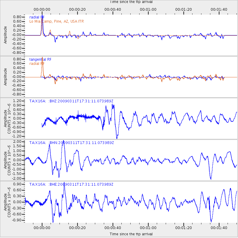
Signal To Noise
| Channel | StoN | STA | LTA |
| TA:X16A: :BHN:20090311T17:31:11.073989Z | 3.1315498 | 6.8820873E-7 | 2.1976616E-7 |
| TA:X16A: :BHE:20090311T17:31:11.073989Z | 1.5294511 | 2.2342911E-7 | 1.460845E-7 |
| TA:X16A: :BHZ:20090311T17:31:11.073989Z | 1.256712 | 2.3568272E-7 | 1.8753917E-7 |
| Arrivals |
| Ps | 1.7 SECOND |
| PpPs | 6.0 SECOND |
| PsPs/PpSs | 7.7 SECOND |


