You are here: Home > Network List > AV - Alaska Volcano Observatory Stations List
> Station AMKA Regional Station, Amchitka Island, Alaska > Earthquake Result Viewer
AMKA Regional Station, Amchitka Island, Alaska - Earthquake Result Viewer
| Earthquake location: |
Southeast Of Ryukyu Islands |
| Earthquake latitude/longitude: |
26.9/130.2 |
| Earthquake time(UTC): |
2017/07/26 (207) 10:32:57 GMT |
| Earthquake Depth: |
10 km |
| Earthquake Magnitude: |
5.9 Mww |
| Earthquake Catalog/Contributor: |
NEIC PDE/us |
|
| Network: |
AV Alaska Volcano Observatory |
| Station: |
AMKA Regional Station, Amchitka Island, Alaska |
| Lat/Lon: |
51.38 N/179.30 E |
| Elevation: |
116 m |
|
| Distance: |
44.2 deg |
| Az: |
42.837 deg |
| Baz: |
255.61 deg |
| Ray Param: |
0.0720781 |
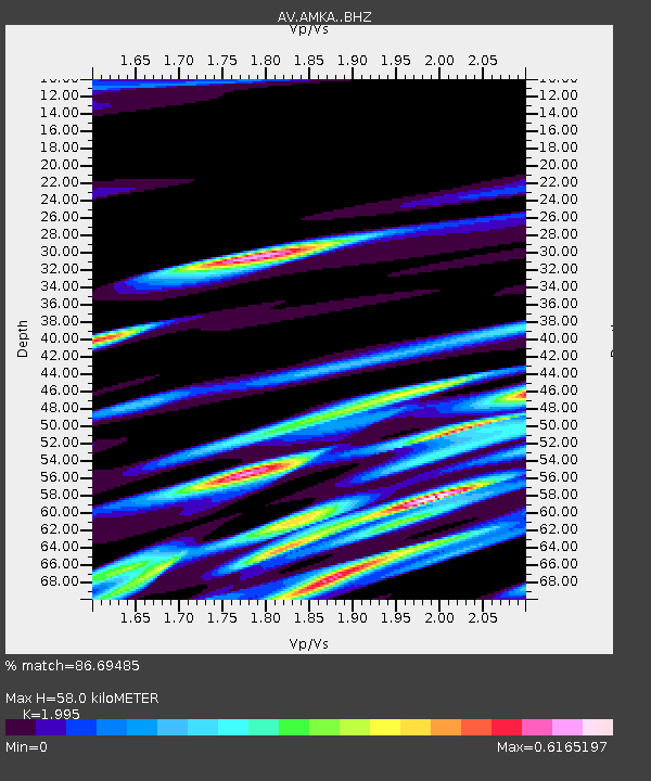
| Estimated Moho Depth: |
58.0 km |
| Estimated Crust Vp/Vs: |
2.00 |
| Assumed Crust Vp: |
6.183 km/s |
| Estimated Crust Vs: |
3.099 km/s |
| Estimated Crust Poisson's Ratio: |
0.33 |
|
| Radial Match: |
86.69485 % |
| Radial Bump: |
400 |
| Transverse Match: |
86.433876 % |
| Transverse Bump: |
400 |
| SOD ConfigId: |
13570011 |
| Insert Time: |
2019-04-28 11:21:08.760 +0000 |
| GWidth: |
2.5 |
| Max Bumps: |
400 |
| Tol: |
0.001 |
|

Signal To Noise
| Channel | StoN | STA | LTA |
| AV:AMKA: :BHZ:20170726T10:40:35.259995Z | 15.016258 | 8.7634885E-7 | 5.8359998E-8 |
| AV:AMKA: :BHN:20170726T10:40:35.259995Z | 2.7674913 | 1.3378101E-7 | 4.8340176E-8 |
| AV:AMKA: :BHE:20170726T10:40:35.259995Z | 6.7989893 | 3.4797293E-7 | 5.11801E-8 |
| Arrivals |
| Ps | 9.8 SECOND |
| PpPs | 27 SECOND |
| PsPs/PpSs | 36 SECOND |


