You are here: Home > Network List > AV - Alaska Volcano Observatory Stations List
> Station SPCR Ckakachatna River, Mount Spurr, Alaska > Earthquake Result Viewer
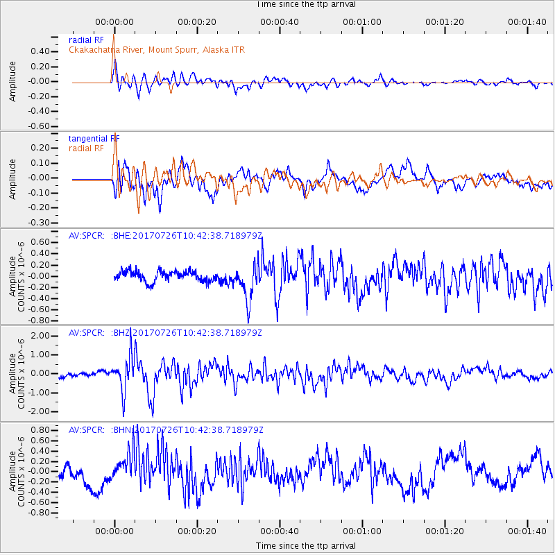
SPCR Ckakachatna River, Mount Spurr, Alaska - Earthquake Result Viewer
*The percent match for this event was below the threshold and hence no stack was calculated.
| Earthquake location: |
Southeast Of Ryukyu Islands |
| Earthquake latitude/longitude: |
26.9/130.2 |
| Earthquake time(UTC): |
2017/07/26 (207) 10:32:57 GMT |
| Earthquake Depth: |
10 km |
| Earthquake Magnitude: |
5.9 Mww |
| Earthquake Catalog/Contributor: |
NEIC PDE/us |
|
| Network: |
AV Alaska Volcano Observatory |
| Station: |
SPCR Ckakachatna River, Mount Spurr, Alaska |
| Lat/Lon: |
61.20 N/152.21 W |
| Elevation: |
984 m |
|
| Distance: |
60.9 deg |
| Az: |
32.782 deg |
| Baz: |
273.304 deg |
| Ray Param: |
$rayparam |
*The percent match for this event was below the threshold and hence was not used in the summary stack. |
|
| Radial Match: |
76.28764 % |
| Radial Bump: |
400 |
| Transverse Match: |
60.328686 % |
| Transverse Bump: |
400 |
| SOD ConfigId: |
13570011 |
| Insert Time: |
2019-04-28 11:21:20.283 +0000 |
| GWidth: |
2.5 |
| Max Bumps: |
400 |
| Tol: |
0.001 |
|
Signal To Noise
| Channel | StoN | STA | LTA |
| AV:SPCR: :BHZ:20170726T10:42:38.718979Z | 11.189106 | 9.4249293E-7 | 8.4233086E-8 |
| AV:SPCR: :BHN:20170726T10:42:38.718979Z | 2.2511406 | 3.1963614E-7 | 1.4198854E-7 |
| AV:SPCR: :BHE:20170726T10:42:38.718979Z | 3.6453376 | 3.322563E-7 | 9.1145544E-8 |
| Arrivals |
| Ps | |
| PpPs | |
| PsPs/PpSs | |


