You are here: Home > Network List > US - United States National Seismic Network Stations List
> Station MNTX Cornudas Mountains, Texas, USA > Earthquake Result Viewer
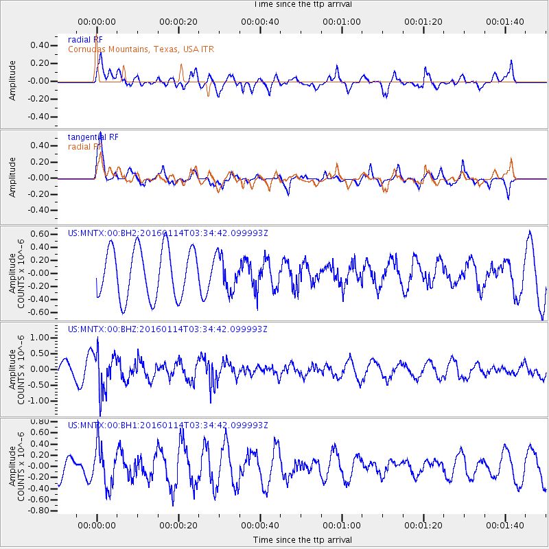
MNTX Cornudas Mountains, Texas, USA - Earthquake Result Viewer
*The percent match for this event was below the threshold and hence no stack was calculated.
| Earthquake location: |
Southern Bolivia |
| Earthquake latitude/longitude: |
-19.8/-63.3 |
| Earthquake time(UTC): |
2016/01/14 (014) 03:25:28 GMT |
| Earthquake Depth: |
582 km |
| Earthquake Magnitude: |
6.1 MWW, 6.1 MWB |
| Earthquake Catalog/Contributor: |
NEIC PDE/NEIC COMCAT |
|
| Network: |
US United States National Seismic Network |
| Station: |
MNTX Cornudas Mountains, Texas, USA |
| Lat/Lon: |
31.70 N/105.38 W |
| Elevation: |
404 m |
|
| Distance: |
65.2 deg |
| Az: |
320.995 deg |
| Baz: |
135.961 deg |
| Ray Param: |
$rayparam |
*The percent match for this event was below the threshold and hence was not used in the summary stack. |
|
| Radial Match: |
56.174515 % |
| Radial Bump: |
400 |
| Transverse Match: |
68.25137 % |
| Transverse Bump: |
383 |
| SOD ConfigId: |
1399611 |
| Insert Time: |
2016-01-28 04:12:48.139 +0000 |
| GWidth: |
2.5 |
| Max Bumps: |
400 |
| Tol: |
0.001 |
|
Signal To Noise
| Channel | StoN | STA | LTA |
| US:MNTX:00:BHZ:20160114T03:34:42.099993Z | 2.4332218 | 6.099727E-7 | 2.506852E-7 |
| US:MNTX:00:BH1:20160114T03:34:42.099993Z | 1.7033122 | 3.6497596E-7 | 2.1427427E-7 |
| US:MNTX:00:BH2:20160114T03:34:42.099993Z | 0.70201266 | 2.666867E-7 | 3.7988872E-7 |
| Arrivals |
| Ps | |
| PpPs | |
| PsPs/PpSs | |


