You are here: Home > Network List > CI - Caltech Regional Seismic Network Stations List
> Station MUR Murrieta > Earthquake Result Viewer
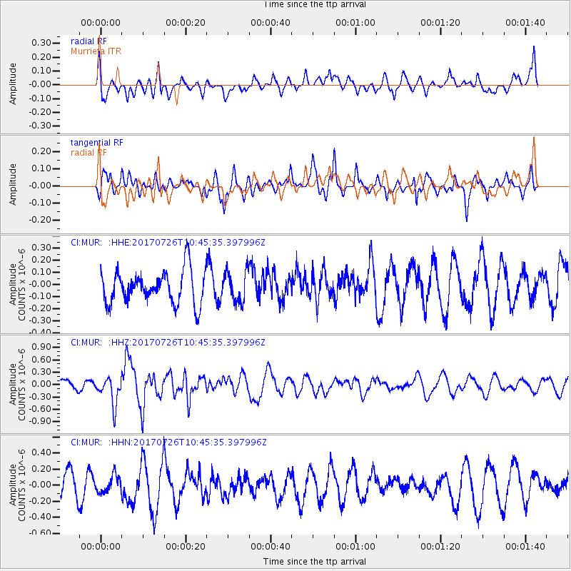
MUR Murrieta - Earthquake Result Viewer
*The percent match for this event was below the threshold and hence no stack was calculated.
| Earthquake location: |
Southeast Of Ryukyu Islands |
| Earthquake latitude/longitude: |
26.9/130.2 |
| Earthquake time(UTC): |
2017/07/26 (207) 10:32:57 GMT |
| Earthquake Depth: |
10 km |
| Earthquake Magnitude: |
5.9 Mww |
| Earthquake Catalog/Contributor: |
NEIC PDE/us |
|
| Network: |
CI Caltech Regional Seismic Network |
| Station: |
MUR Murrieta |
| Lat/Lon: |
33.60 N/117.20 W |
| Elevation: |
562 m |
|
| Distance: |
92.2 deg |
| Az: |
50.446 deg |
| Baz: |
304.43 deg |
| Ray Param: |
$rayparam |
*The percent match for this event was below the threshold and hence was not used in the summary stack. |
|
| Radial Match: |
47.702255 % |
| Radial Bump: |
400 |
| Transverse Match: |
63.93853 % |
| Transverse Bump: |
400 |
| SOD ConfigId: |
13570011 |
| Insert Time: |
2019-04-28 11:22:16.175 +0000 |
| GWidth: |
2.5 |
| Max Bumps: |
400 |
| Tol: |
0.001 |
|
Signal To Noise
| Channel | StoN | STA | LTA |
| CI:MUR: :HHZ:20170726T10:45:35.397996Z | 1.8321198 | 3.4364365E-7 | 1.8756614E-7 |
| CI:MUR: :HHN:20170726T10:45:35.397996Z | 0.58772254 | 1.076973E-7 | 1.8324516E-7 |
| CI:MUR: :HHE:20170726T10:45:35.397996Z | 0.9885784 | 1.3570121E-7 | 1.3726904E-7 |
| Arrivals |
| Ps | |
| PpPs | |
| PsPs/PpSs | |


