You are here: Home > Network List > CI - Caltech Regional Seismic Network Stations List
> Station TUQ Turquiose Mountain, Baker, CA, USA > Earthquake Result Viewer
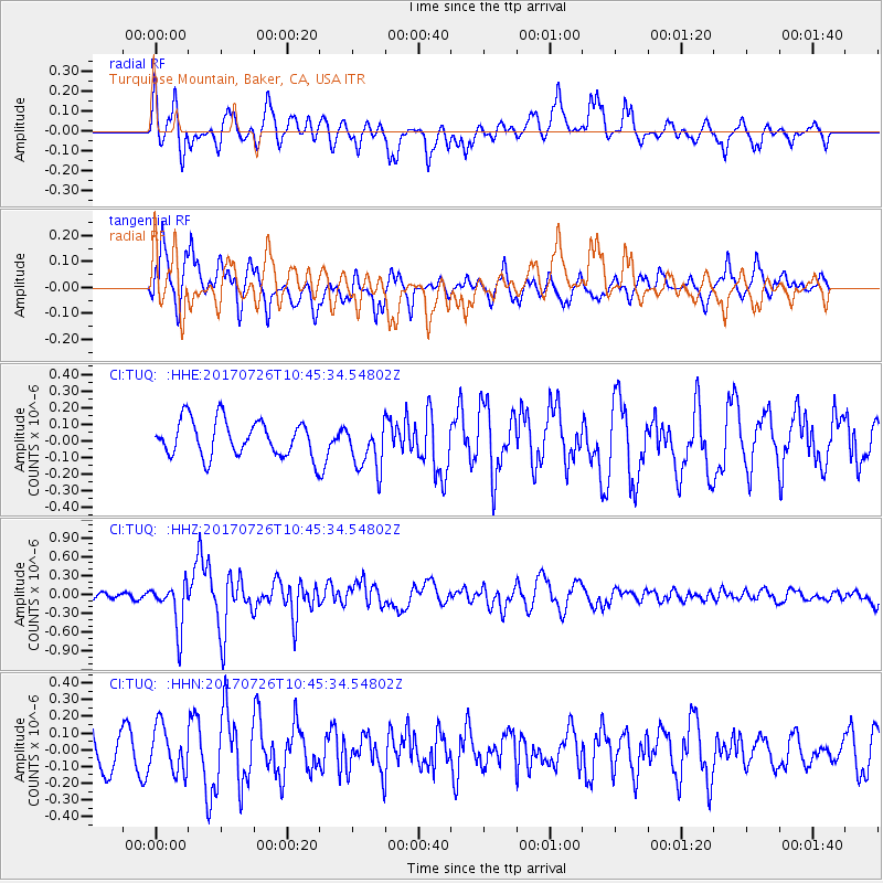
TUQ Turquiose Mountain, Baker, CA, USA - Earthquake Result Viewer
*The percent match for this event was below the threshold and hence no stack was calculated.
| Earthquake location: |
Southeast Of Ryukyu Islands |
| Earthquake latitude/longitude: |
26.9/130.2 |
| Earthquake time(UTC): |
2017/07/26 (207) 10:32:57 GMT |
| Earthquake Depth: |
10 km |
| Earthquake Magnitude: |
5.9 Mww |
| Earthquake Catalog/Contributor: |
NEIC PDE/us |
|
| Network: |
CI Caltech Regional Seismic Network |
| Station: |
TUQ Turquiose Mountain, Baker, CA, USA |
| Lat/Lon: |
35.44 N/115.92 W |
| Elevation: |
1350 m |
|
| Distance: |
92.0 deg |
| Az: |
48.342 deg |
| Baz: |
305.225 deg |
| Ray Param: |
$rayparam |
*The percent match for this event was below the threshold and hence was not used in the summary stack. |
|
| Radial Match: |
54.198784 % |
| Radial Bump: |
400 |
| Transverse Match: |
66.64362 % |
| Transverse Bump: |
400 |
| SOD ConfigId: |
13570011 |
| Insert Time: |
2019-04-28 11:22:27.957 +0000 |
| GWidth: |
2.5 |
| Max Bumps: |
400 |
| Tol: |
0.001 |
|
Signal To Noise
| Channel | StoN | STA | LTA |
| CI:TUQ: :HHZ:20170726T10:45:34.54802Z | 4.262414 | 3.6191167E-7 | 8.4907676E-8 |
| CI:TUQ: :HHN:20170726T10:45:34.54802Z | 1.3287818 | 1.368983E-7 | 1.0302542E-7 |
| CI:TUQ: :HHE:20170726T10:45:34.54802Z | 1.3322768 | 1.4824901E-7 | 1.1127493E-7 |
| Arrivals |
| Ps | |
| PpPs | |
| PsPs/PpSs | |


