You are here: Home > Network List > TA - USArray Transportable Network (new EarthScope stations) Stations List
> Station X16A Lo Mia Camp, Pine, AZ, USA > Earthquake Result Viewer
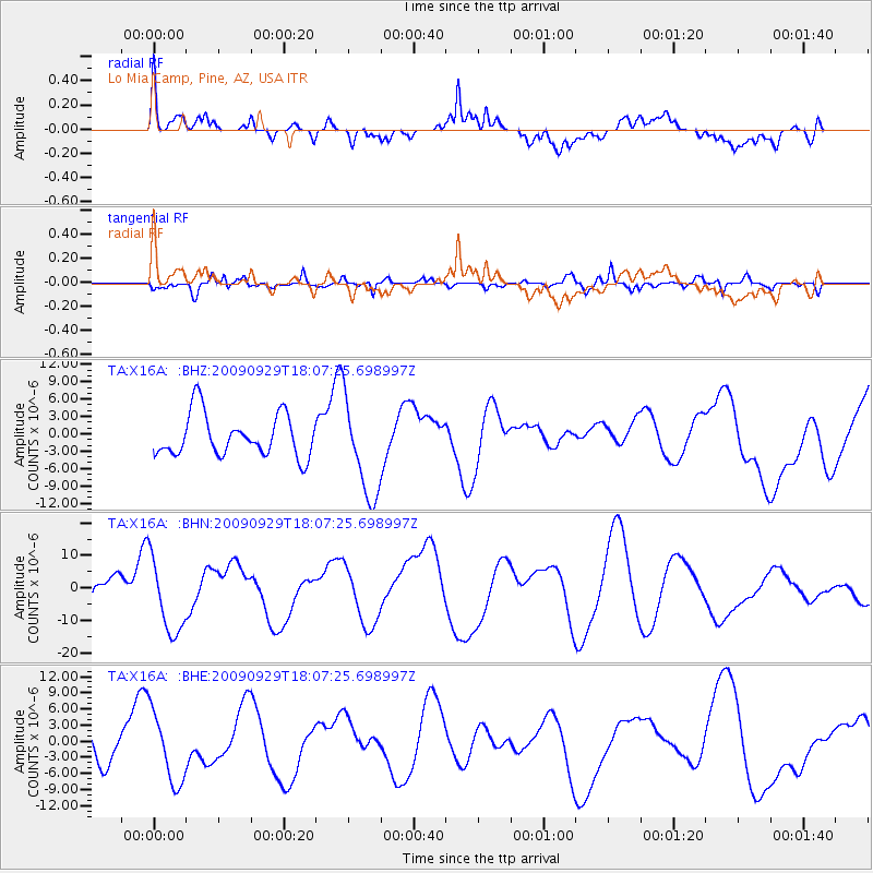
X16A Lo Mia Camp, Pine, AZ, USA - Earthquake Result Viewer
*The percent match for this event was below the threshold and hence no stack was calculated.
| Earthquake location: |
Tonga Islands |
| Earthquake latitude/longitude: |
-15.4/-173.2 |
| Earthquake time(UTC): |
2009/09/29 (272) 17:56:05 GMT |
| Earthquake Depth: |
10 km |
| Earthquake Magnitude: |
6.0 MB |
| Earthquake Catalog/Contributor: |
WHDF/NEIC |
|
| Network: |
TA USArray Transportable Network (new EarthScope stations) |
| Station: |
X16A Lo Mia Camp, Pine, AZ, USA |
| Lat/Lon: |
34.42 N/111.44 W |
| Elevation: |
1759 m |
|
| Distance: |
76.7 deg |
| Az: |
48.421 deg |
| Baz: |
240.804 deg |
| Ray Param: |
$rayparam |
*The percent match for this event was below the threshold and hence was not used in the summary stack. |
|
| Radial Match: |
56.67246 % |
| Radial Bump: |
400 |
| Transverse Match: |
57.202263 % |
| Transverse Bump: |
358 |
| SOD ConfigId: |
2622 |
| Insert Time: |
2010-03-06 02:17:20.699 +0000 |
| GWidth: |
2.5 |
| Max Bumps: |
400 |
| Tol: |
0.001 |
|
Signal To Noise
| Channel | StoN | STA | LTA |
| TA:X16A: :BHN:20090929T18:07:25.698997Z | 1.4136823 | 1.1603101E-5 | 8.207714E-6 |
| TA:X16A: :BHE:20090929T18:07:25.698997Z | 2.2864332 | 6.5741688E-6 | 2.8752945E-6 |
| TA:X16A: :BHZ:20090929T18:07:25.698997Z | 2.3410895 | 8.42877E-6 | 3.6003623E-6 |
| Arrivals |
| Ps | |
| PpPs | |
| PsPs/PpSs | |


