You are here: Home > Network List > TA - USArray Transportable Network (new EarthScope stations) Stations List
> Station H24K Noodor Dome, AK, USA > Earthquake Result Viewer
H24K Noodor Dome, AK, USA - Earthquake Result Viewer

| Earthquake location: |
Southeast Of Ryukyu Islands |
| Earthquake latitude/longitude: |
26.9/130.2 |
| Earthquake time(UTC): |
2017/07/26 (207) 10:32:57 GMT |
| Earthquake Depth: |
10 km |
| Earthquake Magnitude: |
5.9 Mww |
| Earthquake Catalog/Contributor: |
NEIC PDE/us |
|
| Network: |
TA USArray Transportable Network (new EarthScope stations) |
| Station: |
H24K Noodor Dome, AK, USA |
| Lat/Lon: |
65.84 N/147.88 W |
| Elevation: |
814 m |
|
| Distance: |
62.5 deg |
| Az: |
27.357 deg |
| Baz: |
274.603 deg |
| Ray Param: |
0.06019559 |
| Estimated Moho Depth: |
32.5 km |
| Estimated Crust Vp/Vs: |
1.65 |
| Assumed Crust Vp: |
6.566 km/s |
| Estimated Crust Vs: |
3.973 km/s |
| Estimated Crust Poisson's Ratio: |
0.21 |
|
| Radial Match: |
91.41735 % |
| Radial Bump: |
400 |
| Transverse Match: |
79.68813 % |
| Transverse Bump: |
400 |
| SOD ConfigId: |
13570011 |
| Insert Time: |
2019-04-28 11:27:36.120 +0000 |
| GWidth: |
2.5 |
| Max Bumps: |
400 |
| Tol: |
0.001 |
|
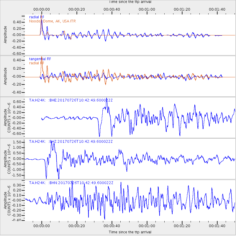
Signal To Noise
| Channel | StoN | STA | LTA |
| TA:H24K: :BHZ:20170726T10:42:49.600022Z | 15.338935 | 5.4983883E-7 | 3.584596E-8 |
| TA:H24K: :BHN:20170726T10:42:49.600022Z | 1.6395788 | 6.033574E-8 | 3.6799538E-8 |
| TA:H24K: :BHE:20170726T10:42:49.600022Z | 8.293946 | 2.651976E-7 | 3.197484E-8 |
| Arrivals |
| Ps | 3.4 SECOND |
| PpPs | 12 SECOND |
| PsPs/PpSs | 16 SECOND |


