You are here: Home > Network List > TA - USArray Transportable Network (new EarthScope stations) Stations List
> Station HARP HAARP, Gakona, AK, USA > Earthquake Result Viewer
HARP HAARP, Gakona, AK, USA - Earthquake Result Viewer
| Earthquake location: |
Southeast Of Ryukyu Islands |
| Earthquake latitude/longitude: |
26.9/130.2 |
| Earthquake time(UTC): |
2017/07/26 (207) 10:32:57 GMT |
| Earthquake Depth: |
10 km |
| Earthquake Magnitude: |
5.9 Mww |
| Earthquake Catalog/Contributor: |
NEIC PDE/us |
|
| Network: |
TA USArray Transportable Network (new EarthScope stations) |
| Station: |
HARP HAARP, Gakona, AK, USA |
| Lat/Lon: |
62.40 N/145.16 W |
| Elevation: |
581 m |
|
| Distance: |
64.1 deg |
| Az: |
31.04 deg |
| Baz: |
278.706 deg |
| Ray Param: |
0.059161082 |
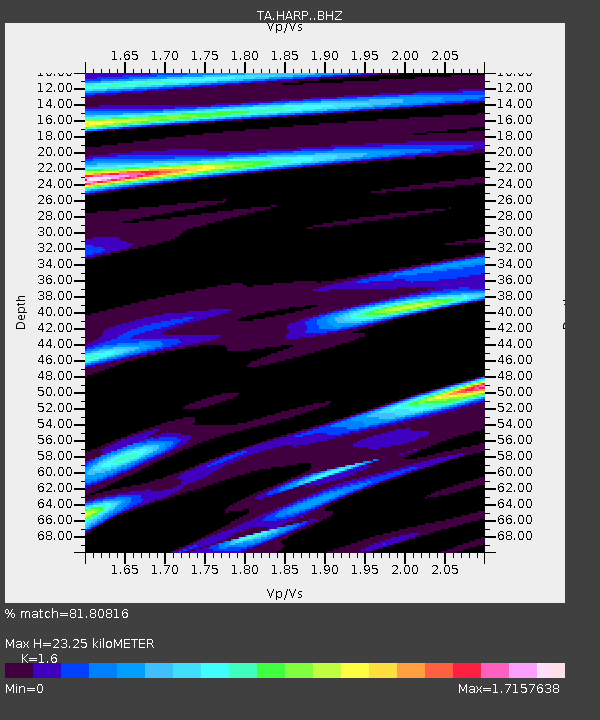
| Estimated Moho Depth: |
23.25 km |
| Estimated Crust Vp/Vs: |
1.60 |
| Assumed Crust Vp: |
6.566 km/s |
| Estimated Crust Vs: |
4.104 km/s |
| Estimated Crust Poisson's Ratio: |
0.18 |
|
| Radial Match: |
81.80816 % |
| Radial Bump: |
400 |
| Transverse Match: |
69.42551 % |
| Transverse Bump: |
400 |
| SOD ConfigId: |
13570011 |
| Insert Time: |
2019-04-28 11:27:37.940 +0000 |
| GWidth: |
2.5 |
| Max Bumps: |
400 |
| Tol: |
0.001 |
|

Signal To Noise
| Channel | StoN | STA | LTA |
| TA:HARP: :BHZ:20170726T10:43:00.100022Z | 5.9030824 | 9.876559E-7 | 1.6731188E-7 |
| TA:HARP: :BHN:20170726T10:43:00.100022Z | 1.8813466 | 2.9067039E-7 | 1.5450125E-7 |
| TA:HARP: :BHE:20170726T10:43:00.100022Z | 3.7850177 | 3.838714E-7 | 1.0141865E-7 |
| Arrivals |
| Ps | 2.2 SECOND |
| PpPs | 8.8 SECOND |
| PsPs/PpSs | 11 SECOND |


