You are here: Home > Network List > TA - USArray Transportable Network (new EarthScope stations) Stations List
> Station L14K Kuka Creek, AK, USA > Earthquake Result Viewer
L14K Kuka Creek, AK, USA - Earthquake Result Viewer
| Earthquake location: |
Southeast Of Ryukyu Islands |
| Earthquake latitude/longitude: |
26.9/130.2 |
| Earthquake time(UTC): |
2017/07/26 (207) 10:32:57 GMT |
| Earthquake Depth: |
10 km |
| Earthquake Magnitude: |
5.9 Mww |
| Earthquake Catalog/Contributor: |
NEIC PDE/us |
|
| Network: |
TA USArray Transportable Network (new EarthScope stations) |
| Station: |
L14K Kuka Creek, AK, USA |
| Lat/Lon: |
61.34 N/162.68 W |
| Elevation: |
41 m |
|
| Distance: |
55.8 deg |
| Az: |
32.475 deg |
| Baz: |
263.966 deg |
| Ray Param: |
0.06454692 |
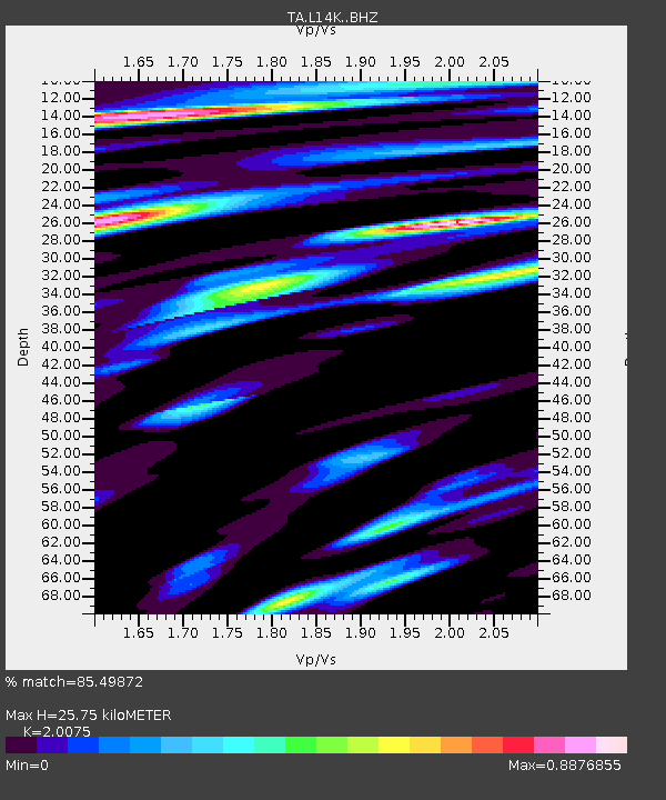
| Estimated Moho Depth: |
25.75 km |
| Estimated Crust Vp/Vs: |
2.01 |
| Assumed Crust Vp: |
6.1 km/s |
| Estimated Crust Vs: |
3.039 km/s |
| Estimated Crust Poisson's Ratio: |
0.33 |
|
| Radial Match: |
85.49872 % |
| Radial Bump: |
400 |
| Transverse Match: |
81.26587 % |
| Transverse Bump: |
400 |
| SOD ConfigId: |
13570011 |
| Insert Time: |
2019-04-28 11:27:59.989 +0000 |
| GWidth: |
2.5 |
| Max Bumps: |
400 |
| Tol: |
0.001 |
|

Signal To Noise
| Channel | StoN | STA | LTA |
| TA:L14K: :BHZ:20170726T10:42:03.52501Z | 7.2783294 | 7.8949E-7 | 1.08471326E-7 |
| TA:L14K: :BHN:20170726T10:42:03.52501Z | 1.4441118 | 1.4747607E-7 | 1.02122335E-7 |
| TA:L14K: :BHE:20170726T10:42:03.52501Z | 4.2707047 | 4.0474725E-7 | 9.4772936E-8 |
| Arrivals |
| Ps | 4.4 SECOND |
| PpPs | 12 SECOND |
| PsPs/PpSs | 17 SECOND |


