You are here: Home > Network List > TA - USArray Transportable Network (new EarthScope stations) Stations List
> Station O19K Port Alsworth, AK, USA > Earthquake Result Viewer
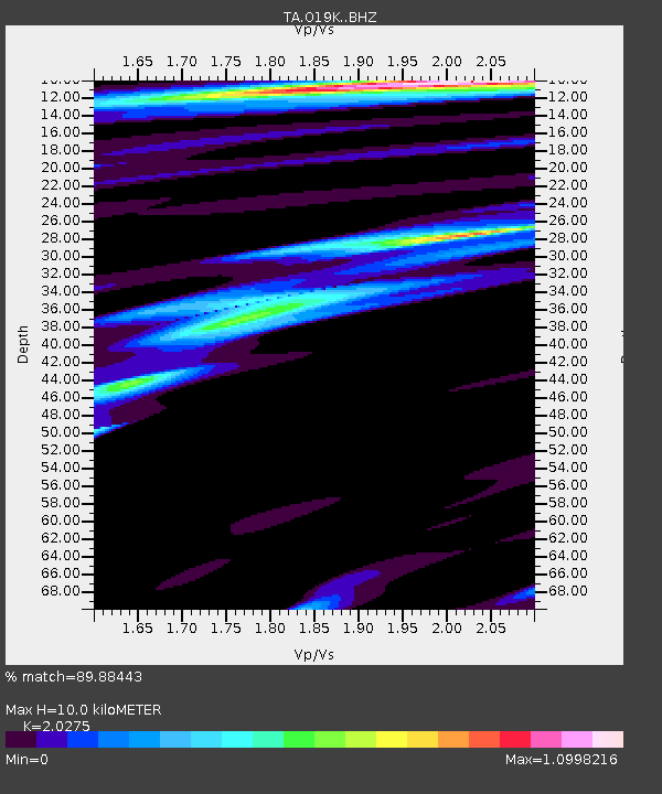
O19K Port Alsworth, AK, USA - Earthquake Result Viewer
| Earthquake location: |
Southeast Of Ryukyu Islands |
| Earthquake latitude/longitude: |
26.9/130.2 |
| Earthquake time(UTC): |
2017/07/26 (207) 10:32:57 GMT |
| Earthquake Depth: |
10 km |
| Earthquake Magnitude: |
5.9 Mww |
| Earthquake Catalog/Contributor: |
NEIC PDE/us |
|
| Network: |
TA USArray Transportable Network (new EarthScope stations) |
| Station: |
O19K Port Alsworth, AK, USA |
| Lat/Lon: |
60.20 N/154.32 W |
| Elevation: |
96 m |
|
| Distance: |
59.9 deg |
| Az: |
33.997 deg |
| Baz: |
272.066 deg |
| Ray Param: |
0.06190081 |
| Estimated Moho Depth: |
10.0 km |
| Estimated Crust Vp/Vs: |
2.03 |
| Assumed Crust Vp: |
6.566 km/s |
| Estimated Crust Vs: |
3.239 km/s |
| Estimated Crust Poisson's Ratio: |
0.34 |
|
| Radial Match: |
89.88443 % |
| Radial Bump: |
400 |
| Transverse Match: |
77.7416 % |
| Transverse Bump: |
400 |
| SOD ConfigId: |
13570011 |
| Insert Time: |
2019-04-28 11:28:35.001 +0000 |
| GWidth: |
2.5 |
| Max Bumps: |
400 |
| Tol: |
0.001 |
|

Signal To Noise
| Channel | StoN | STA | LTA |
| TA:O19K: :BHZ:20170726T10:42:31.975022Z | 14.408727 | 7.752142E-7 | 5.3801713E-8 |
| TA:O19K: :BHN:20170726T10:42:31.975022Z | 2.0324595 | 1.6188521E-7 | 7.96499E-8 |
| TA:O19K: :BHE:20170726T10:42:31.975022Z | 7.7199993 | 5.1695315E-7 | 6.696285E-8 |
| Arrivals |
| Ps | 1.6 SECOND |
| PpPs | 4.4 SECOND |
| PsPs/PpSs | 6.1 SECOND |


