You are here: Home > Network List > TA - USArray Transportable Network (new EarthScope stations) Stations List
> Station O29M Mount Kennedy, YT, CAN > Earthquake Result Viewer
O29M Mount Kennedy, YT, CAN - Earthquake Result Viewer
| Earthquake location: |
Southeast Of Ryukyu Islands |
| Earthquake latitude/longitude: |
26.9/130.2 |
| Earthquake time(UTC): |
2017/07/26 (207) 10:32:57 GMT |
| Earthquake Depth: |
10 km |
| Earthquake Magnitude: |
5.9 Mww |
| Earthquake Catalog/Contributor: |
NEIC PDE/us |
|
| Network: |
TA USArray Transportable Network (new EarthScope stations) |
| Station: |
O29M Mount Kennedy, YT, CAN |
| Lat/Lon: |
60.30 N/138.58 W |
| Elevation: |
1423 m |
|
| Distance: |
67.6 deg |
| Az: |
32.576 deg |
| Baz: |
285.104 deg |
| Ray Param: |
0.056846175 |
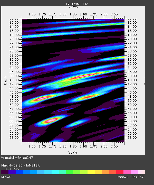
| Estimated Moho Depth: |
59.25 km |
| Estimated Crust Vp/Vs: |
1.75 |
| Assumed Crust Vp: |
6.566 km/s |
| Estimated Crust Vs: |
3.763 km/s |
| Estimated Crust Poisson's Ratio: |
0.26 |
|
| Radial Match: |
84.66147 % |
| Radial Bump: |
400 |
| Transverse Match: |
87.71325 % |
| Transverse Bump: |
400 |
| SOD ConfigId: |
13570011 |
| Insert Time: |
2019-04-28 11:28:38.491 +0000 |
| GWidth: |
2.5 |
| Max Bumps: |
400 |
| Tol: |
0.001 |
|
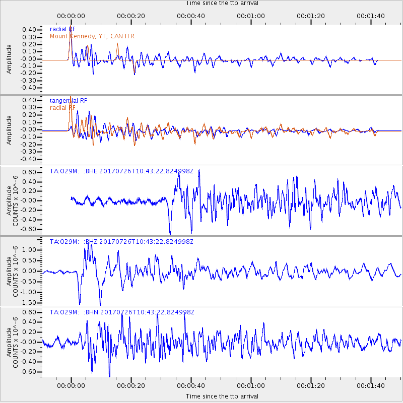
Signal To Noise
| Channel | StoN | STA | LTA |
| TA:O29M: :BHZ:20170726T10:43:22.824998Z | 9.150809 | 5.7463996E-7 | 6.279662E-8 |
| TA:O29M: :BHN:20170726T10:43:22.824998Z | 1.6133746 | 7.548559E-8 | 4.678739E-8 |
| TA:O29M: :BHE:20170726T10:43:22.824998Z | 5.4784923 | 2.4888337E-7 | 4.542917E-8 |
| Arrivals |
| Ps | 7.0 SECOND |
| PpPs | 24 SECOND |
| PsPs/PpSs | 31 SECOND |


